A1 · Beginner
Jebel Barkal: Holy Mountain and Ancient Pyramids
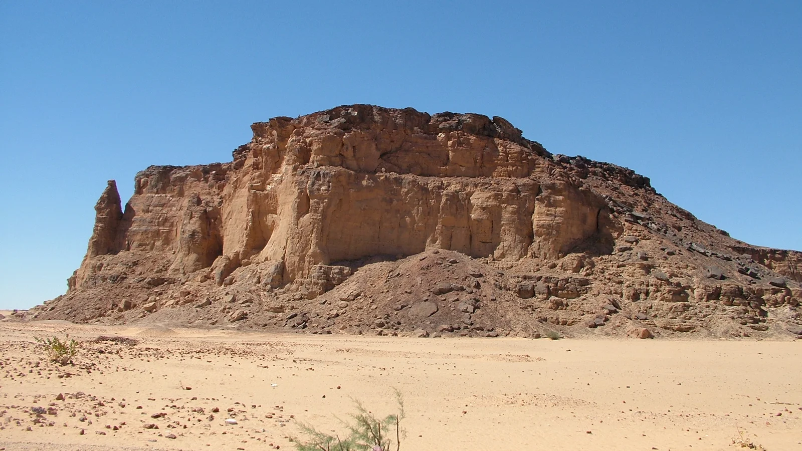
Jebel Barkal is a tall sandstone mountain by the Nile where ancient kings built large temples and royal pyramids.
Sacred Topography and Sandstone Geology
Jebel Barkal is a tall red sandstone mountain near Karima town.
Ancient people believed the holy mountain was a home for gods.
A tall stone pinnacle looks like a royal snake with a crown.
Desert wind and seasonal rain wash over the red cliff rocks.
The high mountain summit commands panoramic views across the Nile bend and palm basins.
World heritage leaders protect the ancient mountain site in Sudan.
Amun Temple and Napatan Monuments
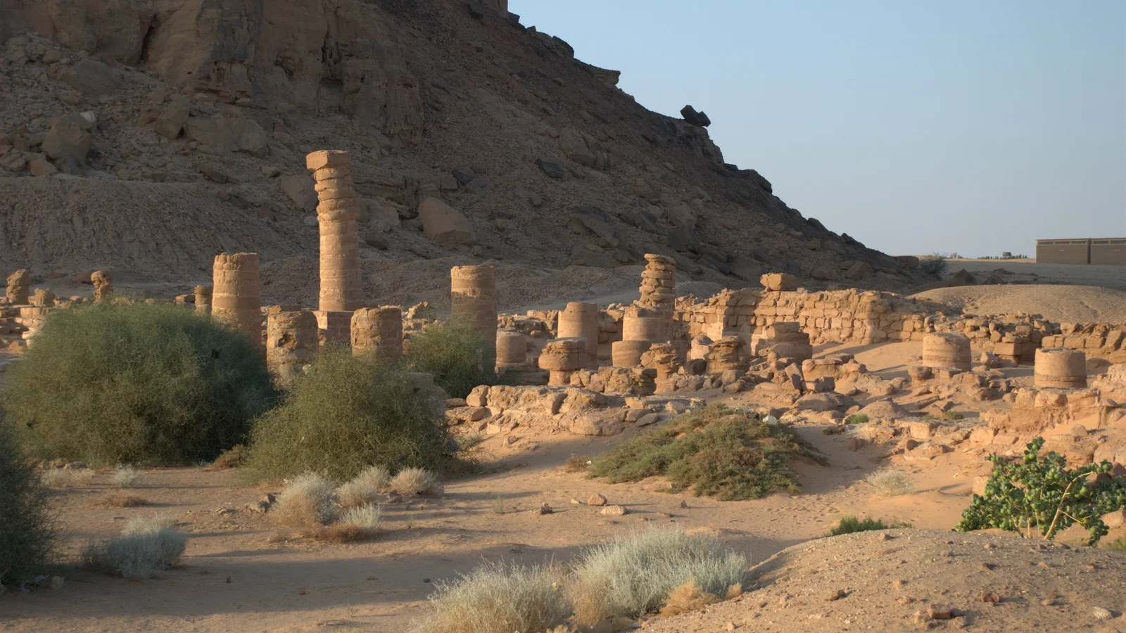
A large ancient Amun temple stands at the foot of the mountain.
Great Kushite kings celebrated imperial coronation ceremonies inside the Amun sanctuary.
Italian mission excavations found tall column halls and royal stone slabs.
The smaller Mut temple has bright stone carvings inside mountain rock.
Stone ram statues and royal altars once lined the path to the river.
Conservation teams monitor rising groundwater levels and salt to protect temple walls.
Royal Pyramids and Desert Necropolis
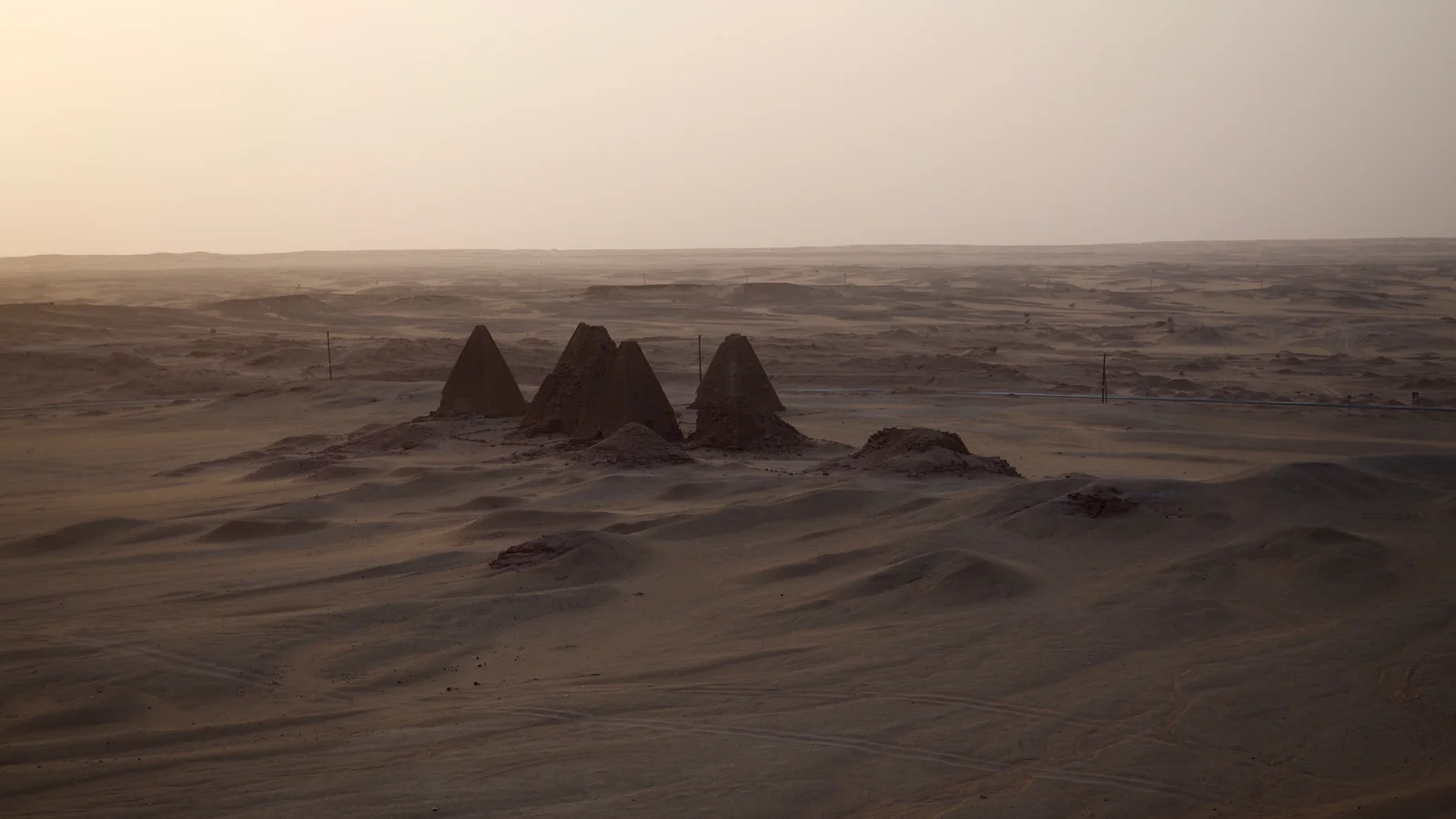
Two groups of royal stone pyramids stand on the desert plateau.
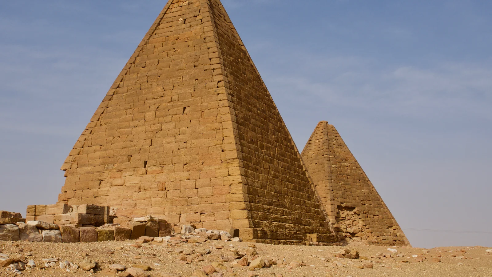
Over twenty tall sandstone pyramids were built for royal kings.
Deep underground burial rooms have old painted words on stone ceilings.
Small stone chapels stand in front of each royal desert pyramid.
Workers cut heavy stone blocks from ridges and moved them on rollers.
Park guards watch blowing sand and sun heat to keep pyramids safe.
Working Landscape and Riverine Ecology
Town farmers grow green date palms and wheat near the river bank.
Water pumps bring river water to green vegetable gardens each morning.
Local farm families help protect ancient ruins from new city building.
Townspeople walk up the mountain to enjoy cool evening sunset breezes.
Old stone ruins and green farm fields live peacefully together here.
Heritage stewardship guidelines protect both community agricultural lands and ancient stone temples.
A2 · Elementary
Jebel Barkal Sacred Landscapes: Temples, Pyramids, and Living Riverine Ecology
Rising above the Nile bend near Karima, Jebel Barkal anchors monumental Kushite coronation temples and steep desert pyramids.
Sacred Topography and Sandstone Geology
Jebel Barkal is an isolated red sandstone butte rising ninety-eight meters above the Nile floodplain near the modern town of Karima in Northern State. Ancient Nubian and Egyptian theologians revered the mountain as the primeval southern dwelling of the ram-headed deity Amun. A distinctive sixty-meter sandstone pinnacle at the southwestern face of the mountain resembles an erect royal uraeus cobra wearing the white crown.
Wind erosion, diurnal thermal expansion, and flash rainwater runoff continuously weather the friable sandstone cliff faces and talus slopes. The summit of Jebel Barkal commands panoramic sightlines across the Great Nile Bend, prehistoric trade tracks, and alluvial palm basins. UNESCO inscribed Jebel Barkal and the Sites of the Napatan Region on the World Heritage List in 2003 under international cultural criteria.
Amun Temple and Napatan Monuments
At the southeastern foot of the mountain lies the Great Temple of Amun, initially established during the Egyptian New Kingdom and expanded by Kushite kings. King Piye and his royal successor Taharqa embellished the Amun sanctuary into the principal imperial coronation center for the Twenty-Fifth Dynasty of Egypt and Kush. Excavations directed by George Reisner and later the Italian archaeological mission uncovered palace foundations, hypostyle column halls, monumental pylons, and royal stelae.
The Temple of Mut, carved directly into the mountain base, preserves vibrant relief carvings of goddess Hathor sistrum columns and Queen Takahatenamun. Monumental stone ram statues, granite victory altars, and carved royal barque stands once lined the paved processional dromos leading to the river. Structural conservation campaigns managed by the National Corporation for Antiquities and Museums monitor rising groundwater levels and salt efflorescence.
Royal Pyramids and Desert Necropolis
Two distinct royal pyramid fields, designated the Northern and Southern groups, stand across the western desert plateau of Jebel Barkal as an expansive royal necropolis. Over twenty steep-sided sandstone pyramids with slope angles approaching seventy degrees served as funerary monuments for Kushite kings and queens. Subterranean burial chambers carved into bedrock beneath the pyramids featured vaulted ceilings decorated with painted excerpts from funerary texts.
Each pyramid was fronted by an east-facing offering chapel containing carved stone false doors and scenes of royal mortuary rituals with sandstone chapels. Sandstone blocks for pyramid masonry were quarried directly from surrounding desert ridges and transported across desert tracks using wooden rollers. Contemporary archaeological monitoring tracks windblown desert sand accumulation and thermal fracturing threatening the structural stability of the pyramid masonry.
Working Landscape and Riverine Ecology
Modern agricultural communities in Karima and neighboring villages cultivate narrow, fertile date palm groves and wheat fields between the mountain and the Nile. Traditional diesel pumps and solar-assisted irrigation canals draw water from the Nile to nourish vegetable plots immediately bordering the archaeological zone. Local farmers and heritage custodians cooperate with archaeological missions to safeguard the boundary buffer zones against uncontrolled urban encroachment.
Jebel Barkal remains an integral living landmark where townspeople gather for evening walks and community cultural celebrations on the sandstone plateau. The confluence of desert topography, ancient stone monumentalism, and active irrigation agriculture embodies the millennia-long human adaptation to the Middle Nile. Heritage stewardship programs balance community agricultural land rights with scientific preservation mandates outlined in state conservation guidelines.
B1 · Intermediate
Napatan Sacred Geography, Monumental Architecture, and Riverine Continuity at Jebel Barkal
An analytical study of Nubian coronation rituals, Amun hypostyle sanctuaries, royal pyramid necropolises, and modern oasis agriculture.
Sacred Topography and Sandstone Geology
Jebel Barkal is an isolated red sandstone butte rising ninety-eight meters above the Nile floodplain near the modern town of Karima in Northern State. Ancient Nubian and Egyptian theologians revered the mountain as the primeval southern dwelling of the ram-headed deity Amun. A distinctive sixty-meter sandstone pinnacle at the southwestern face of the mountain resembles an erect royal uraeus cobra wearing the white crown.
Wind erosion, diurnal thermal expansion, and flash rainwater runoff continuously weather the friable sandstone cliff faces and talus slopes. The summit of Jebel Barkal commands panoramic sightlines across the Great Nile Bend, prehistoric trade tracks, and alluvial palm basins. UNESCO inscribed Jebel Barkal and the Sites of the Napatan Region on the World Heritage List in 2003 under international cultural criteria.
Amun Temple and Napatan Monuments
At the southeastern foot of the mountain lies the Great Temple of Amun, initially established during the Egyptian New Kingdom and expanded by Kushite kings. King Piye and his royal successor Taharqa embellished the Amun sanctuary into the principal imperial coronation center for the Twenty-Fifth Dynasty of Egypt and Kush. Excavations directed by George Reisner and later the Italian archaeological mission uncovered palace foundations, hypostyle column halls, monumental pylons, and royal stelae.
The Temple of Mut, carved directly into the mountain base, preserves vibrant relief carvings of goddess Hathor sistrum columns and Queen Takahatenamun. Monumental stone ram statues, granite victory altars, and carved royal barque stands once lined the paved processional dromos leading to the river. Structural conservation campaigns managed by the National Corporation for Antiquities and Museums monitor rising groundwater levels and salt efflorescence.
Royal Pyramids and Desert Necropolis
Two distinct royal pyramid fields, designated the Northern and Southern groups, stand across the western desert plateau of Jebel Barkal as an expansive royal necropolis. Over twenty steep-sided sandstone pyramids with slope angles approaching seventy degrees served as funerary monuments for Kushite kings and queens. Subterranean burial chambers carved into bedrock beneath the pyramids featured vaulted ceilings decorated with painted excerpts from funerary texts.
Each pyramid was fronted by an east-facing offering chapel containing carved stone false doors and scenes of royal mortuary rituals with sandstone chapels. Sandstone blocks for pyramid masonry were quarried directly from surrounding desert ridges and transported across desert tracks using wooden rollers. Contemporary archaeological monitoring tracks windblown desert sand accumulation and thermal fracturing threatening the structural stability of the pyramid masonry.
Working Landscape and Riverine Ecology
Modern agricultural communities in Karima and neighboring villages cultivate narrow, fertile date palm groves and wheat fields between the mountain and the Nile. Traditional diesel pumps and solar-assisted irrigation canals draw water from the Nile to nourish vegetable plots immediately bordering the archaeological zone. Local farmers and heritage custodians cooperate with archaeological missions to safeguard the boundary buffer zones against uncontrolled urban encroachment.
Jebel Barkal remains an integral living landmark where townspeople gather for evening walks and community cultural celebrations on the sandstone plateau. The confluence of desert topography, ancient stone monumentalism, and active irrigation agriculture embodies the millennia-long human adaptation to the Middle Nile. Heritage stewardship programs balance community agricultural land rights with scientific preservation mandates outlined in state conservation guidelines.
B2 · Upper Intermediate
Kushite Imperial Ideology, Monumental Preservation, and Agrarian Stewardship around Jebel Barkal
Investigating pharaonic and Kushite temple engineering, sandstone pyramid quarrying techniques, groundwater salinity monitoring, and community land buffer zones.
Sacred Topography and Sandstone Geology
Jebel Barkal is an isolated red sandstone butte rising ninety-eight meters above the Nile floodplain near the modern town of Karima in Northern State. Ancient Nubian and Egyptian theologians revered the mountain as the primeval southern dwelling of the ram-headed deity Amun. A distinctive sixty-meter sandstone pinnacle at the southwestern face of the mountain resembles an erect royal uraeus cobra wearing the white crown.
Wind erosion, diurnal thermal expansion, and flash rainwater runoff continuously weather the friable sandstone cliff faces and talus slopes. The summit of Jebel Barkal commands panoramic sightlines across the Great Nile Bend, prehistoric trade tracks, and alluvial palm basins. UNESCO inscribed Jebel Barkal and the Sites of the Napatan Region on the World Heritage List in 2003 under international cultural criteria.
Amun Temple and Napatan Monuments
At the southeastern foot of the mountain lies the Great Temple of Amun, initially established during the Egyptian New Kingdom and expanded by Kushite kings. King Piye and his royal successor Taharqa embellished the Amun sanctuary into the principal imperial coronation center for the Twenty-Fifth Dynasty of Egypt and Kush. Excavations directed by George Reisner and later the Italian archaeological mission uncovered palace foundations, hypostyle column halls, monumental pylons, and royal stelae.
The Temple of Mut, carved directly into the mountain base, preserves vibrant relief carvings of goddess Hathor sistrum columns and Queen Takahatenamun. Monumental stone ram statues, granite victory altars, and carved royal barque stands once lined the paved processional dromos leading to the river. Structural conservation campaigns managed by the National Corporation for Antiquities and Museums monitor rising groundwater levels and salt efflorescence.
Royal Pyramids and Desert Necropolis
Two distinct royal pyramid fields, designated the Northern and Southern groups, stand across the western desert plateau of Jebel Barkal as an expansive royal necropolis. Over twenty steep-sided sandstone pyramids with slope angles approaching seventy degrees served as funerary monuments for Kushite kings and queens. Subterranean burial chambers carved into bedrock beneath the pyramids featured vaulted ceilings decorated with painted excerpts from funerary texts.
Each pyramid was fronted by an east-facing offering chapel containing carved stone false doors and scenes of royal mortuary rituals with sandstone chapels. Sandstone blocks for pyramid masonry were quarried directly from surrounding desert ridges and transported across desert tracks using wooden rollers. Contemporary archaeological monitoring tracks windblown desert sand accumulation and thermal fracturing threatening the structural stability of the pyramid masonry.
Working Landscape and Riverine Ecology
Modern agricultural communities in Karima and neighboring villages cultivate narrow, fertile date palm groves and wheat fields between the mountain and the Nile. Traditional diesel pumps and solar-assisted irrigation canals draw water from the Nile to nourish vegetable plots immediately bordering the archaeological zone. Local farmers and heritage custodians cooperate with archaeological missions to safeguard the boundary buffer zones against uncontrolled urban encroachment.
Jebel Barkal remains an integral living landmark where townspeople gather for evening walks and community cultural celebrations on the sandstone plateau. The confluence of desert topography, ancient stone monumentalism, and active irrigation agriculture embodies the millennia-long human adaptation to the Middle Nile. Heritage stewardship programs balance community agricultural land rights with scientific preservation mandates outlined in state conservation guidelines.
C1 · Advanced
Theocratic Landscape Morphology, Kushite Imperial Monumentalism, and Preservation Dynamics at Jebel Barkal
A critical examination of sacred butte topography, Twenty-Fifth Dynasty coronation architecture, necropolis construction mechanics, and contemporary heritage stewardship.
Sacred Topography and Sandstone Geology
Jebel Barkal is an isolated red sandstone butte rising ninety-eight meters above the Nile floodplain near the modern town of Karima in Northern State. Ancient Nubian and Egyptian theologians revered the mountain as the primeval southern dwelling of the ram-headed deity Amun. A distinctive sixty-meter sandstone pinnacle at the southwestern face of the mountain resembles an erect royal uraeus cobra wearing the white crown.
Wind erosion, diurnal thermal expansion, and flash rainwater runoff continuously weather the friable sandstone cliff faces and talus slopes. The summit of Jebel Barkal commands panoramic sightlines across the Great Nile Bend, prehistoric trade tracks, and alluvial palm basins. UNESCO inscribed Jebel Barkal and the Sites of the Napatan Region on the World Heritage List in 2003 under international cultural criteria.
Amun Temple and Napatan Monuments
At the southeastern foot of the mountain lies the Great Temple of Amun, initially established during the Egyptian New Kingdom and expanded by Kushite kings. King Piye and his royal successor Taharqa embellished the Amun sanctuary into the principal imperial coronation center for the Twenty-Fifth Dynasty of Egypt and Kush. Excavations directed by George Reisner and later the Italian archaeological mission uncovered palace foundations, hypostyle column halls, monumental pylons, and royal stelae.
The Temple of Mut, carved directly into the mountain base, preserves vibrant relief carvings of goddess Hathor sistrum columns and Queen Takahatenamun. Monumental stone ram statues, granite victory altars, and carved royal barque stands once lined the paved processional dromos leading to the river. Structural conservation campaigns managed by the National Corporation for Antiquities and Museums monitor rising groundwater levels and salt efflorescence.
Royal Pyramids and Desert Necropolis
Two distinct royal pyramid fields, designated the Northern and Southern groups, stand across the western desert plateau of Jebel Barkal as an expansive royal necropolis. Over twenty steep-sided sandstone pyramids with slope angles approaching seventy degrees served as funerary monuments for Kushite kings and queens. Subterranean burial chambers carved into bedrock beneath the pyramids featured vaulted ceilings decorated with painted excerpts from funerary texts.
Each pyramid was fronted by an east-facing offering chapel containing carved stone false doors and scenes of royal mortuary rituals with sandstone chapels. Sandstone blocks for pyramid masonry were quarried directly from surrounding desert ridges and transported across desert tracks using wooden rollers. Contemporary archaeological monitoring tracks windblown desert sand accumulation and thermal fracturing threatening the structural stability of the pyramid masonry.
Working Landscape and Riverine Ecology
Modern agricultural communities in Karima and neighboring villages cultivate narrow, fertile date palm groves and wheat fields between the mountain and the Nile. Traditional diesel pumps and solar-assisted irrigation canals draw water from the Nile to nourish vegetable plots immediately bordering the archaeological zone. Local farmers and heritage custodians cooperate with archaeological missions to safeguard the boundary buffer zones against uncontrolled urban encroachment.
Jebel Barkal remains an integral living landmark where townspeople gather for evening walks and community cultural celebrations on the sandstone plateau. The confluence of desert topography, ancient stone monumentalism, and active irrigation agriculture embodies the millennia-long human adaptation to the Middle Nile. Heritage stewardship programs balance community agricultural land rights with scientific preservation mandates outlined in state conservation guidelines.
C2 · Mastery
Sacral Topography, Kushite Imperial Coronation Mechanics, and Agrarian Ecology at Jebel Barkal
A comprehensive analytical monograph detailing Napatan theocratic landscapes, Amun temple epigraphy, royal pyramid structural dynamics, and Nile floodplain adaptations.
Sacred Topography and Sandstone Geology
Jebel Barkal is an isolated red sandstone butte rising ninety-eight meters above the Nile floodplain near the modern town of Karima in Northern State. Ancient Nubian and Egyptian theologians revered the mountain as the primeval southern dwelling of the ram-headed deity Amun. A distinctive sixty-meter sandstone pinnacle at the southwestern face of the mountain resembles an erect royal uraeus cobra wearing the white crown.
Wind erosion, diurnal thermal expansion, and flash rainwater runoff continuously weather the friable sandstone cliff faces and talus slopes. The summit of Jebel Barkal commands panoramic sightlines across the Great Nile Bend, prehistoric trade tracks, and alluvial palm basins. UNESCO inscribed Jebel Barkal and the Sites of the Napatan Region on the World Heritage List in 2003 under international cultural criteria.
Amun Temple and Napatan Monuments
At the southeastern foot of the mountain lies the Great Temple of Amun, initially established during the Egyptian New Kingdom and expanded by Kushite kings. King Piye and his royal successor Taharqa embellished the Amun sanctuary into the principal imperial coronation center for the Twenty-Fifth Dynasty of Egypt and Kush. Excavations directed by George Reisner and later the Italian archaeological mission uncovered palace foundations, hypostyle column halls, monumental pylons, and royal stelae.
The Temple of Mut, carved directly into the mountain base, preserves vibrant relief carvings of goddess Hathor sistrum columns and Queen Takahatenamun. Monumental stone ram statues, granite victory altars, and carved royal barque stands once lined the paved processional dromos leading to the river. Structural conservation campaigns managed by the National Corporation for Antiquities and Museums monitor rising groundwater levels and salt efflorescence.
Royal Pyramids and Desert Necropolis
Two distinct royal pyramid fields, designated the Northern and Southern groups, stand across the western desert plateau of Jebel Barkal as an expansive royal necropolis. Over twenty steep-sided sandstone pyramids with slope angles approaching seventy degrees served as funerary monuments for Kushite kings and queens. Subterranean burial chambers carved into bedrock beneath the pyramids featured vaulted ceilings decorated with painted excerpts from funerary texts.
Each pyramid was fronted by an east-facing offering chapel containing carved stone false doors and scenes of royal mortuary rituals with sandstone chapels. Sandstone blocks for pyramid masonry were quarried directly from surrounding desert ridges and transported across desert tracks using wooden rollers. Contemporary archaeological monitoring tracks windblown desert sand accumulation and thermal fracturing threatening the structural stability of the pyramid masonry.
Working Landscape and Riverine Ecology
Modern agricultural communities in Karima and neighboring villages cultivate narrow, fertile date palm groves and wheat fields between the mountain and the Nile. Traditional diesel pumps and solar-assisted irrigation canals draw water from the Nile to nourish vegetable plots immediately bordering the archaeological zone. Local farmers and heritage custodians cooperate with archaeological missions to safeguard the boundary buffer zones against uncontrolled urban encroachment.
Jebel Barkal remains an integral living landmark where townspeople gather for evening walks and community cultural celebrations on the sandstone plateau. The confluence of desert topography, ancient stone monumentalism, and active irrigation agriculture embodies the millennia-long human adaptation to the Middle Nile. Heritage stewardship programs balance community agricultural land rights with scientific preservation mandates outlined in state conservation guidelines.
Check your understanding
Choose how closely you want to revisit the article. You can refer back while answering, and review explanations when you finish.
Quick Quiz A1
Try one question, then create a free account for the full Quick Quiz. Sign Up Free
Answer every question before checking. There is no time limit.
Your results
/ 1 correct (%)
Read the explanations to see how each answer connects to the article.
-
Where does the tall red sandstone mountain of Jebel Barkal sit?
1. Answer:
Quick Quiz A2
Try one question, then create a free account for the full Quick Quiz. Sign Up Free
Answer every question before checking. There is no time limit.
Your results
/ 1 correct (%)
Read the explanations to see how each answer connects to the article.
-
How high does the sandstone butte of Jebel Barkal rise above the Nile floodplain?
1. Answer:
Quick Quiz B1
Try one question, then create a free account for the full Quick Quiz. Sign Up Free
Answer every question before checking. There is no time limit.
Your results
/ 1 correct (%)
Read the explanations to see how each answer connects to the article.
-
How high does the sandstone butte of Jebel Barkal rise above the Nile floodplain?
1. Answer:
Quick Quiz B2
Try one question, then create a free account for the full Quick Quiz. Sign Up Free
Answer every question before checking. There is no time limit.
Your results
/ 1 correct (%)
Read the explanations to see how each answer connects to the article.
-
How high does the sandstone butte of Jebel Barkal rise above the Nile floodplain?
1. Answer:
Quick Quiz C1
Try one question, then create a free account for the full Quick Quiz. Sign Up Free
Answer every question before checking. There is no time limit.
Your results
/ 1 correct (%)
Read the explanations to see how each answer connects to the article.
-
How high does the sandstone butte of Jebel Barkal rise above the Nile floodplain?
1. Answer:
Quick Quiz C2
Try one question, then create a free account for the full Quick Quiz. Sign Up Free
Answer every question before checking. There is no time limit.
Your results
/ 1 correct (%)
Read the explanations to see how each answer connects to the article.
-
How high does the sandstone butte of Jebel Barkal rise above the Nile floodplain?
1. Answer:
