A1 · Beginner
The Twelve Apostles on the Great Ocean Road
See the tall yellow rock stacks standing in the wild ocean along the southern coast.
Tall Rock Stacks in the Sea
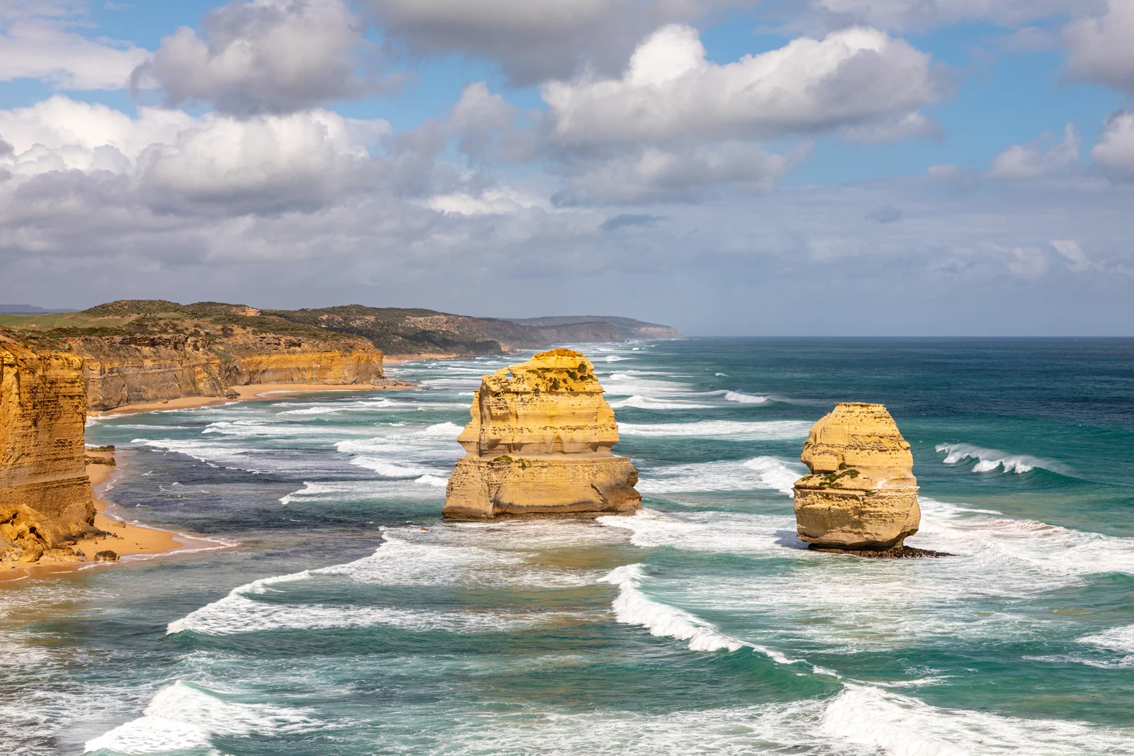
The Twelve Apostles are giant limestone rock pillars that stand in the blue ocean.
The cliffs are made of soft yellow stone and hard mud layers from an ancient sea.
Some of these huge stone pillars rise up to forty-five meters above the water.
People named them the Twelve Apostles in the 1920s, but there were only nine rocks.
Salt from sea water gets into tiny cracks and breaks the stone over many years.
Victoria made Port Campbell National Park in 1964 to keep the yellow cliffs safe.
How Waves Break the Stone
Big ocean waves from the cold south crash hard against the stone cliffs every day.
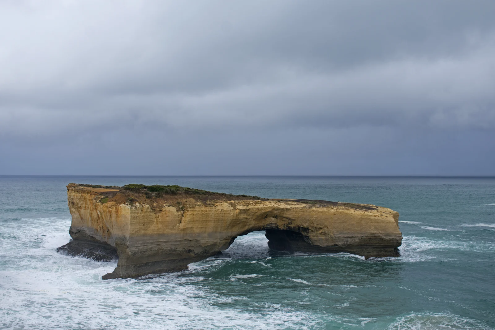
Rushing waves carve dark caves into arches that fall down to leave tall stone pillars.
In July 2005, one tall fifty-meter stone stack fell down into the sea in seconds.
Part of the stone bridge called London Bridge fell into the sea in January 1990.
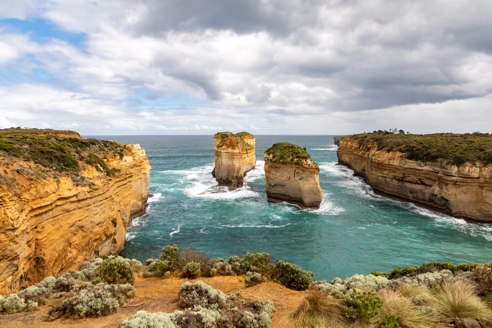
Another stone arch fell down in June 2009, leaving two new separate rocks called Tom and Eva.
Wild ocean water keeps cutting deep holes under the cliffs to make new stone pillars.
A Road Built by Brave Soldiers
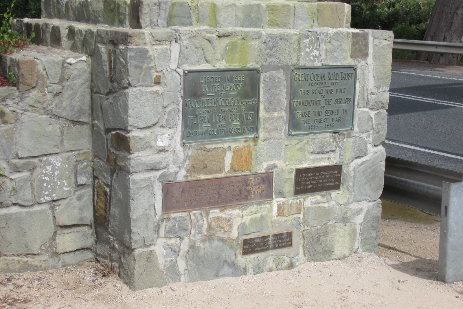
People planned the Great Ocean Road as a war memorial to honor brave soldiers who died in World War One.
More than three thousand returned soldiers built this long road between 1919 and 1932.
The men worked hard with hand picks, shovels, and dynamite along dangerous ocean cliffs.
The scenic coastal road runs for 243 kilometers between the towns of Torquay and Allansford.
The government opened the highway in November 1932 and stopped taking tolls in 1936.
Australia placed the famous highway on the National Heritage List in 2011.
Old Shipwrecks and Nature Paths
Fierce winds and hidden rocks caused more than six hundred shipwrecks along this rocky coast.
A famous ship called the Loch Ard sank in June 1878, and only two teenagers survived.
Gadubanud and Kirrae Whurrong First Nations people lived along these coastal cliffs for thousands of years.
Old mounds of sea shells show where Indigenous families gathered healthy food near the ocean.
The state created Twelve Apostles Marine National Park in 2002 to protect little penguins and fish.
Sturdy wooden walking paths let millions of visitors view the rocks without hurting delicate plants.
A2 · Elementary
Twelve Apostles: Limestone Stacks and Coastal Highway
Discover the ancient geology, dramatic rock collapses, and heroic road engineering of Victoria's Shipwreck Coast.
Miocene Limestone and Coastal Formations
The limestone strata of Port Campbell formed between ten and twenty million years ago in warm Miocene seas.
These coastal cliffs consist of soft calcarenite limestone interspersed with harder clay-rich marl layers.
The freestanding sea stacks of the Twelve Apostles rise up to 45 meters above the Southern Ocean swell.
Despite their modern name, there were only nine standing sea stacks when the landmark was renamed in the 1920s.
Subaerial weathering and salt-spray crystallization gradually widen vertical fractures in the soft limestone.
The Victorian government established Port Campbell National Park in 1964 to preserve this 17-kilometer coastal landscape.
Relentless Wave Action and Arch Collapses
Powerful waves generated in the Southern Ocean erode the base of the limestone cliffs by two centimeters each year.
Marine erosion begins when waves carve sea caves that break through headlands to form arches before collapsing into stacks.
A dramatic collapse occurred in July 2005 when a 50-meter stack crumbled into rubble in front of amazed onlookers.
The mainland arch of London Bridge collapsed suddenly in January 1990, leaving two tourists stranded on the outer span.
In June 2009, the Island Archway collapsed into the sea, leaving two separate stone pillars named Tom and Eva.
Wave undercutting continues along the rocky headlands, ensuring that new stacks will replace those that tumble down.
Building the World's Largest War Memorial
The Great Ocean Road was envisioned as a war memorial honoring Australian soldiers lost during World War One.
More than 3,000 returned soldiers constructed the rugged highway between 1919 and 1932 using hand tools and explosives.
Road builders endured steep coastal bluffs, dense rainforests, and rough bush camps to carve the coastal route.
The completed highway stretches across 243 kilometers, linking the coastal towns of Torquay and Allansford.
Victoria opened the scenic road in November 1932 and eliminated all travel tolls four years later in 1936.
The Commonwealth recognized the extraordinary historical importance of the highway by adding it to the National Heritage List in 2011.
Shipwreck Lore, Indigenous Custody, and Conservation
Treacherous reefs and howling gales caused over 600 shipwrecks along this coastline during the nineteenth century.
The clipper ship Loch Ard wrecked in June 1878, with teenage apprentice Tom Pearce and passenger Eva Carmichael surviving.
Gadubanud and Kirrae Whurrong clans exercised ancestral custody over these cliffs and river mouths for millennia.
Ancient shell middens on the clifftops prove that First Nations communities harvested abalone and shellfish sustainably.
Victoria established the Twelve Apostles Marine National Park in 2002, protecting 7,500 hectares of rich underwater habitat.
Elevated timber boardwalks direct two million annual visitors safely along the headlands, preventing soil erosion.
B1 · Intermediate
Victoria's Twelve Apostles and the Great Ocean Road
A compelling journey through Miocene limestone deposition, relentless marine erosion, and historic road building along the Shipwreck Coast.
Geological Origins of the Port Campbell Limestone
The towering cliffs of Port Campbell originated between 10 and 20 million years ago during the Miocene epoch.
The formation features porous calcarenite limestone interspersed with harder clay-rich marl strata that weather unevenly.
The majestic limestone stacks of the Twelve Apostles rise up to 45 meters above the crashing surf of the Southern Ocean.
Originally known as the Sow and Piglets, the formation comprised only nine standing stacks when renamed in the 1920s.
Subaerial weathering and salt-spray crystallization continually penetrate vertical fractures, weakening the upper cliff ramparts.
Port Campbell National Park was officially established in 1964 to protect this spectacular seventeen-kilometer karst coastline.
Dynamic Wave Forces and Structural Collapses
Relentless swell waves originating in the Southern Ocean exert intense hydraulic pressure, retreating the cliffs by two centimeters annually.
The classic erosional sequence progresses as waves hollow out sea caves, puncture headlands into arches, and isolate freestanding stacks.
In July 2005, a 50-meter-tall stack collapsed catastrophically into a heap of limestone rubble, reducing the group to eight.
The inner arch of London Bridge collapsed without warning in January 1990, stranding two visitors who required helicopter evacuation.
A similar collapse felled Island Archway in June 2009, creating two freestanding limestone pillars officially named Tom and Eva.
Continuous wave undercutting carves deep basal notches along the headlands, preparing future generations of sea stacks.
The Returned Soldiers and the Coastal Highway
Conceived after the First World War, the Great Ocean Road remains the world's largest commemorative war memorial.
Between 1919 and 1932, more than 3,000 returned Australian soldiers constructed the highway using picks, shovels, and gelignite.
Working through sheer coastal bluffs and dense Otway rainforest, the diggers braved harsh weather and isolated coastal camps.
Spanning 243 kilometers, the highway winds along the rugged southern shoreline from Torquay to Allansford.
The scenic thoroughfare officially opened in November 1932, operating under a toll system until public fees ended in 1936.
In 2011, the Australian government inscribed the Great Ocean Road on the National Heritage List for its cultural significance.
Maritime Disasters, Indigenous Heritage, and Marine Protection
Reefs and squalls along the Shipwreck Coast claimed more than 600 vessels during the peak of nineteenth-century maritime trade.
The iron clipper Loch Ard struck Muttonbird Island in June 1878, leaving Tom Pearce and Eva Carmichael as the sole survivors.
The Gadubanud and Kirrae Whurrong peoples maintained deep cultural connections with these coastal wetlands and headlands for thousands of years.
Abundant shell middens across the clifftops provide archaeological testimony of sophisticated seasonal gathering practices.
Twelve Apostles Marine National Park was gazetted in 2002, protecting 7,500 hectares of underwater reefs, rock lobsters, and seabirds.
Extensive raised timber boardwalks manage two million visitors each year, protecting fragile clifftop soils from foot traffic.
B2 · Upper Intermediate
Limestone Monuments of the Great Ocean Road
Examining the fragile geology of the Twelve Apostles, hydraulic coastal erosion, and returned soldier highway engineering in Victoria.
Miocene Karst Deposition and Cliff Stratigraphy
The sedimentary foundations of Port Campbell were deposited in a warm marine basin between 10 and 20 million years ago during the Miocene.
The vertical cliffs comprise porous calcarenite limestone interspersed with harder clay-rich marl beds that create pronounced horizontal bands.
Sculpted by marine forces, the freestanding sea stacks of the Twelve Apostles rise up to 45 meters above the sea surface.
Formerly titled the Sow and Piglets, the formation possessed only nine standing stacks when promoters adopted the apostolic name in the 1920s.
Subaerial weathering processes and salt-spray crystallization exploit structural fractures, initiating mechanical failure along joints.
The Victorian government established Port Campbell National Park in 1964, securing statutory protection across seventeen kilometers of karst cliffs.
Hydraulic Wave Energy and Episodic Collapse
Southern Ocean swell waves generated across the Roaring Forties deliver relentless hydraulic impacts that erode the cliff bases by two centimeters yearly.
The cycle of coastal retreat evolves as waves carve sea caves into natural arches, which eventually collapse into isolated sea stacks.
In July 2005, a prominent 50-meter-tall stack collapsed into rubble within seconds, leaving only eight named apostles standing.
A dramatic failure altered London Bridge in January 1990 when the inner arch collapsed, leaving two tourists isolated on the outer span.
Marine erosion claimed Island Archway in June 2009, transforming a connected arch into two limestone pillars renamed Tom and Eva.
Persistent wave undercutting continues to excavate deep basal slots beneath the headlands, ensuring new stacks will inevitably form.
Commemorative Engineering and Returned Soldier Labor
Conceived as an enduring war memorial, the Great Ocean Road commemorates Australian servicemen who lost their lives in World War One.
From 1919 to 1932, over 3,000 returned Australian soldiers constructed the coastal highway utilizing manual picks, shovels, and explosives.
The construction corps excavated the road through treacherous coastal precipices and temperate rainforest while enduring primitive bush encampments.
Traversing 243 kilometers of Victorian coastline, the highway connects the eastern gateway of Torquay with Allansford near Warrnambool.
The highway opened to traffic in November 1932 under a private trust, which collected vehicle tolls until public ownership began in 1936.
The Commonwealth recognized the engineering achievement and commemorative significance of the road with National Heritage listing in 2011.
Maritime Peril, First Nations Heritage, and Sanctuary Stewardship
Savage gales, dense fog, and limestone reefs made the Shipwreck Coast a maritime graveyard claiming more than 600 vessels.
The tragic wreck of the clipper Loch Ard occurred in June 1878, with apprentice Tom Pearce and passenger Eva Carmichael surviving.
Gadubanud and Kirrae Whurrong Traditional Owners exercised enduring cultural stewardship over these coastal territories across generations.
Extensive shell middens preserved on clifftops provide physical evidence of ancestral harvesting of abalone, mussels, and turbo snails.
The Victorian Parliament established the Twelve Apostles Marine National Park in 2002, protecting 7,500 hectares of pristine ocean habitat.
Networked viewing platforms and elevated timber boardwalks channel over two million tourists annually while safeguarding delicate coastal heathlands.
C1 · Advanced
Victoria's Twelve Apostles and the Great Ocean Road
An analytical study of Miocene calcarenite karst sedimentation, hydraulic wave collapse, and returned soldier highway engineering along the Shipwreck Coast.
Miocene Karst Sedimentation and Stratigraphic Architecture
The sedimentary bedrock of the Port Campbell coast originated between 10 and 20 million years ago from compressed biogenic calcarenite.
The coastal escarpment consists of friable calcarenite limestone interspersed with indurated marl strata that govern differential coastal recession rates.
Rising up to 45 meters above the churning Southern Ocean surf, these iconic limestone sea stacks form dramatic vertical pinnacles.
Historically christened the Sow and Piglets, the formation encompassed precisely nine standing stacks when renamed in the 1920s.
Subaerial weathering mechanisms, combined with salt-spray crystallization, exploit vertical stress fractures within the upper cliff facades.
The Victorian government gazetted Port Campbell National Park in 1964, securing comprehensive ecological protection over seventeen kilometers of karst cliffs.
Hydraulic Geomorphology and Episodic Marine Collapse
High-energy Southern Ocean storm swells deliver immense hydraulic force, driving a baseline cliff recession of two centimeters per year.
The geomorphological sequence progresses systematically as wave undercutting breaches headlands to form arches before detaching freestanding monoliths.
In July 2005, a towering 50-meter sea stack collapsed catastrophically into a pile of limestone rubble, reducing the group to eight.
A spectacular collapse fractured London Bridge in January 1990 when the mainland arch gave way, stranding two tourists on the newly severed span.
Marine erosion severed Island Archway in June 2009, transforming a connected arch into two isolated sea stacks named Tom and Eva.
Relentless wave undercutting along subterranean cliff notches ensures that receding headlands will continually produce successor stacks.
Commemorative Highway Construction and Diggers Labor
The Great Ocean Road was conceived after the Armistice as the world's most expansive war memorial to commemorate fallen soldiers.
Between 1919 and 1932, a workforce exceeding 3,000 returned Australian soldiers constructed the highway utilizing hand picks, shovels, and gelignite.
Road builders hand-carved the carriage route through precipitous coastal bluffs, navigating unstable mudstone and rugged coastal wilderness.
Spanning 243 kilometers along Victoria's shoreline, the transportation artery connects Torquay in the east with Allansford in the west.
Following its official dedication in November 1932, the highway operated under private trust administration until toll gates were abolished in 1936.
The Australian Commonwealth inscribed the Great Ocean Road on the National Heritage List in 2011, recognizing its commemorative resonance.
Shipwreck Antiquity, Indigenous Custodianship, and Park Governance
Lethal oceanic squalls, heavy fog, and uncharted limestone reefs rendered the Shipwreck Coast perilous, claiming over 600 merchant ships.
The catastrophic wreck of the iron clipper Loch Ard unfolded in June 1878, leaving nineteen-year-olds Tom Pearce and Eva Carmichael as sole survivors.
Gadubanud and Kirrae Whurrong First Peoples exercised sovereign custody across these coastal cliffs, littoral wetlands, and marine estuaries for millennia.
Prehistoric shell middens stratified along cliff margins yield archaeological evidence of seasonal foraging for abalone, turbos, and coastal shellfish.
The state gazetted Twelve Apostles Marine National Park in 2002, protecting 7,500 hectares of sub-tidal kelp forests, rock lobsters, and penguin colonies.
Engineered timber boardwalks and cantilevers manage over two million tourists each year, arresting soil degradation across delicate heathlands.
C2 · Mastery
Twelve Apostles and Great Ocean Road: Geology and Memorial
A definitive investigation of Miocene karst sedimentation, dynamic wave undercutting, and returned soldier highway engineering along Victoria's Shipwreck Coast.
Miocene Karst Sedimentation and Structural Lithology
The marine bedrock of Port Campbell originated between 10 and 20 million years ago through biogenic sedimentation in warm Miocene seas.
The cliff sequence features friable calcarenite interspersed with indurated marl strata, producing variable resistance across the vertical rock face.
Sculpted by hydraulic wave attrition, the freestanding sea stacks of the Twelve Apostles rise up to 45 meters above the sea.
Historically known as the Sow and Piglets, the geological archipelago numbered only nine standing stacks when commercialized in the 1920s.
Subaerial weathering processes and salt-spray crystallization aggressively exploit latent fissures within the porous limestone strata.
Victoria gazetted Port Campbell National Park in 1964, establishing statutory protection across seventeen kilometers of vulnerable karst cliffs.
Hydraulic Wave Mechanics and Cataclysmic Collapse Dynamics
Long-period oceanic undulations from the Roaring Forties exert relentless hydraulic attrition, receding the limestone cliff line by two centimeters annually.
The morphological evolution advances inexorably as hydraulic wave forces hollow sea caves into arches that collapse into isolated monoliths.
In July 2005, a cataclysmic structural failure toppled a 50-meter-tall stack into rubble within seconds, reducing the count to eight.
The natural mainland abutments of London Bridge collapsed without warning in January 1990, marooning two visitors on the isolated outer span.
Severe wave pounding claimed Island Archway in June 2009, leaving two freestanding pillars that were subsequently christened Tom and Eva.
Relentless wave undercutting along subterranean cliff notches ensures that incessant marine erosion will generate successor stacks from collapsing headlands.
Commemorative Memorial Highway and Returned Soldier Engineering
Envisioned following the Armistice, the Great Ocean Road serves as an enduring cenotaph and the world's most expansive war memorial, honoring fallen troops.
Between 1919 and 1932, more than 3,000 returned Australian soldiers constructed the highway using hand picks, shovels, and gelignite explosives.
These indomitable road crews hand-carved the scenic carriage route through sheer Otway bluffs while camping in austere bush camps.
Traversing 243 kilometers of dramatic coastal topography, the scenic highway connects Torquay in the east with Allansford in the west.
The completed highway opened in November 1932 under a private trust until the route was consecrated as a toll-free public thoroughfare in 1936.
The Australian Government inscribed the Great Ocean Road on the National Heritage List in 2011, honoring its engineering feat.
Shipwreck Coast Perils, Indigenous Antiquity, and Coastal Stewardship
Violent Southern Ocean tempests and treacherous limestone reefs transformed this coast into a graveyard claiming more than 600 ships.
The legendary maritime catastrophe of the clipper Loch Ard occurred in June 1878, with Tom Pearce and Eva Carmichael surviving.
Gadubanud and Kirrae Whurrong First Peoples maintained unbroken cultural connections and traditional stewardship across these coastal landscapes for millennia.
Stratified shell middens along the cliff edges reveal ancient subsistence patterns focused on coastal abalone, molluscs, and marine sustenance.
The Victorian Parliament established the Twelve Apostles Marine National Park in 2002, protecting 7,500 hectares of fragile kelp forests and penguin rookeries.
Elevated timber boardwalks and scenic viewing platforms channel two million annual visitors safely along the headlands, mitigating soil erosion.
Check your understanding
Choose how closely you want to revisit the article. You can refer back while answering, and review explanations when you finish.
Quick Quiz A1
Try one question, then create a free account for the full Quick Quiz. Sign Up Free
Answer every question before checking. There is no time limit.
Your results
/ 1 correct (%)
Read the explanations to see how each answer connects to the article.
-
What type of rock pillars stand in the blue ocean along the coast?
1. Answer:
Quick Quiz A2
Try one question, then create a free account for the full Quick Quiz. Sign Up Free
Answer every question before checking. There is no time limit.
Your results
/ 1 correct (%)
Read the explanations to see how each answer connects to the article.
-
During which geological epoch did the marine strata of Port Campbell form between ten and twenty million years ago?
1. Answer:
Quick Quiz B1
Try one question, then create a free account for the full Quick Quiz. Sign Up Free
Answer every question before checking. There is no time limit.
Your results
/ 1 correct (%)
Read the explanations to see how each answer connects to the article.
-
During which geological epoch did the towering limestone cliffs of Port Campbell originate?
1. Answer:
Quick Quiz B2
Try one question, then create a free account for the full Quick Quiz. Sign Up Free
Answer every question before checking. There is no time limit.
Your results
/ 1 correct (%)
Read the explanations to see how each answer connects to the article.
-
During which epoch were the marine sedimentary foundations of Port Campbell deposited in a warm basin?
1. Answer:
Quick Quiz C1
Try one question, then create a free account for the full Quick Quiz. Sign Up Free
Answer every question before checking. There is no time limit.
Your results
/ 1 correct (%)
Read the explanations to see how each answer connects to the article.
-
What biogenic rock material formed the sedimentary bedrock of the Port Campbell coast during the Miocene?
1. Answer:
Quick Quiz C2
Try one question, then create a free account for the full Quick Quiz. Sign Up Free
Answer every question before checking. There is no time limit.
Your results
/ 1 correct (%)
Read the explanations to see how each answer connects to the article.
-
During which epoch did biogenic sedimentation form the marine bedrock of Port Campbell?
1. Answer:
