A1 · Beginner
Danube River and Roman Limes Fortifications
How Roman soldiers built strong stone camps, river watchtowers, and the grand city of Carnuntum along the Danube.
The Roman River Border and Guard Towers
Long ago the wide Danube River formed the northern military border of the Roman Empire.
In 2021 UNESCO added the Austrian Danube Limes to the famous World Heritage List.
Roman commanders built stone camps, auxiliary forts, and tall watchtowers along the riverbank.
Fast Roman patrol boats guarded river waters and watched peaceful cargo boats day and night.
Between Passau and Hainburg the Danube cuts past steep rocky hills and flat green fields across Austria.
Modern researchers have discovered more than thirty Roman military forts beside the Danube River.
Carnuntum Capital and the Camp at Vindobona
Carnuntum grew into the largest military base and provincial capital along the Austrian Danube.
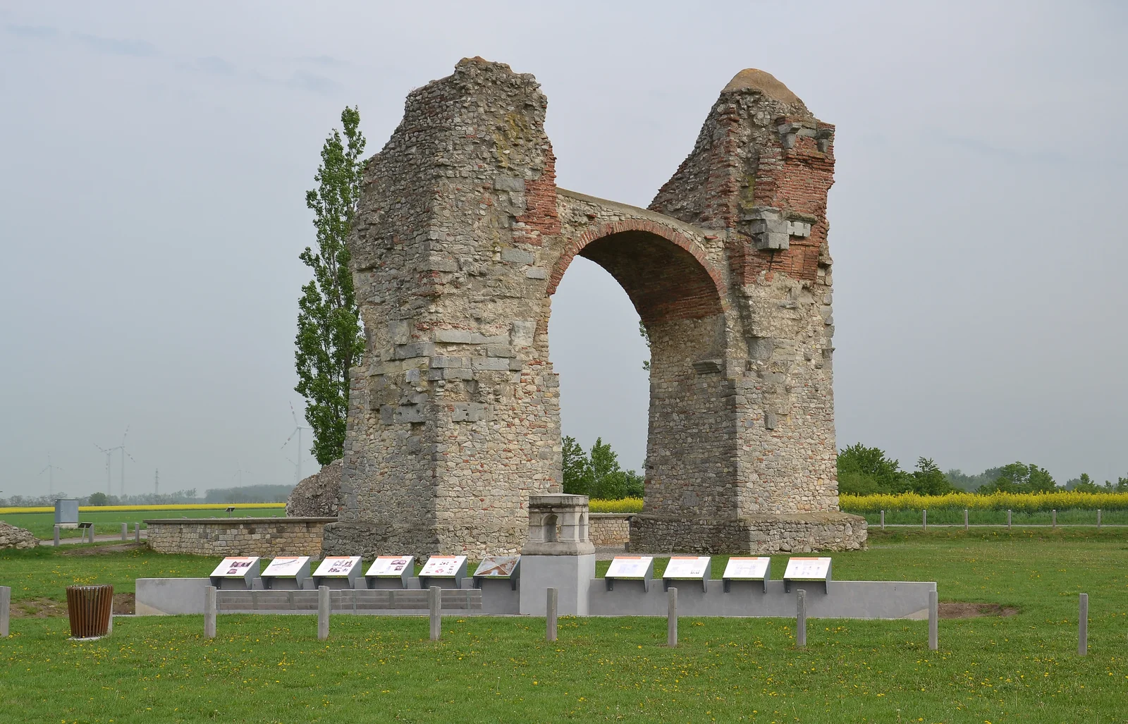
A massive stone triumphal arch called the Heidentor still stands tall in the green fields of Carnuntum.
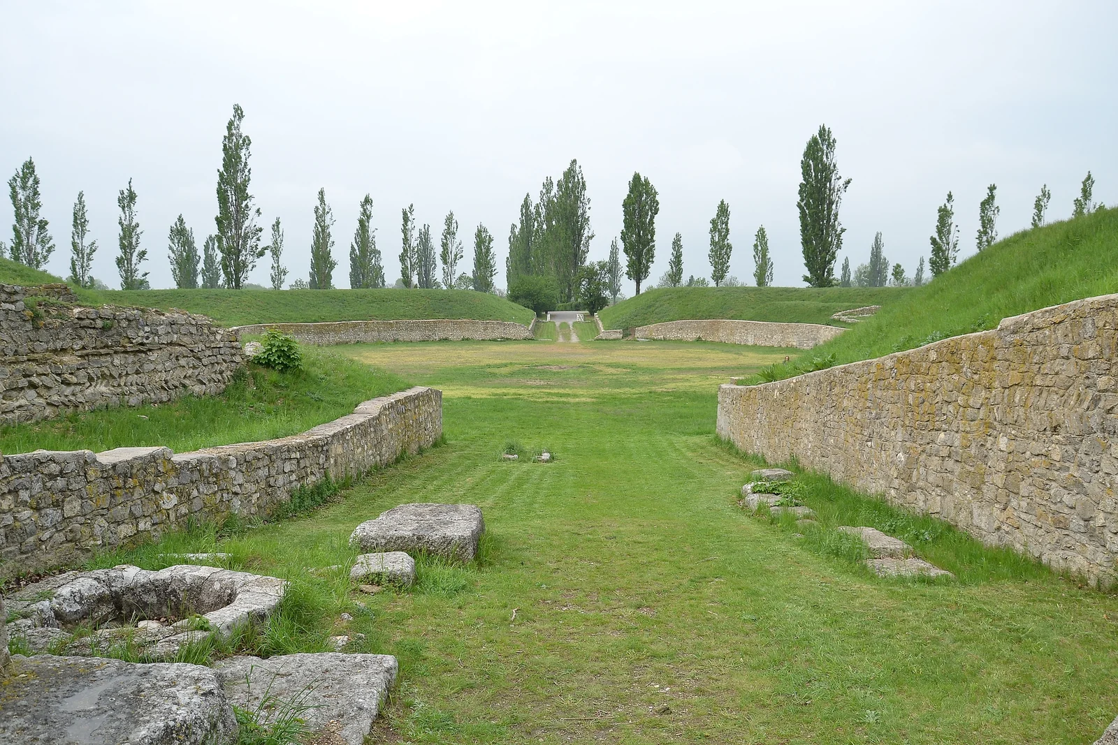
The civilian town at Petronell features rebuilt Roman houses and an amphitheatre for thirteen thousand people.
The city of Vienna began as a Roman fortress named Vindobona guarding the river crossing.
Modern excavations under central Vienna reveal ancient officer rooms, heated floors, and stone walls.
Bustling civilian villages grew near the camps, offering food markets, metal workshops, and inns for soldiers.
River Docks, Cavalry Forts, and Roman Roads
Roman horse soldiers guarded key river crossing points from forts at Tulln and Mautern.
Clever army builders made stone boat landings, docks, and wooden harbors along the river.
In the fourth century Roman engineers built thick round towers that projected outward from fort walls.
A paved stone road connected every military fort to help soldiers march quickly along the river.
Seasonal river floods and muddy waters covered ancient Roman stone walls with thick river silt.
Roman soldiers traded bronze pots and olive oil with Germanic tribes across the wide river.
Protecting Ancient Stones and Welcoming River Cyclists
Special magnetic scans find buried Roman camps without digging up the farm fields.
Heritage protection laws keep ancient Roman fortresses safe from modern building damage.
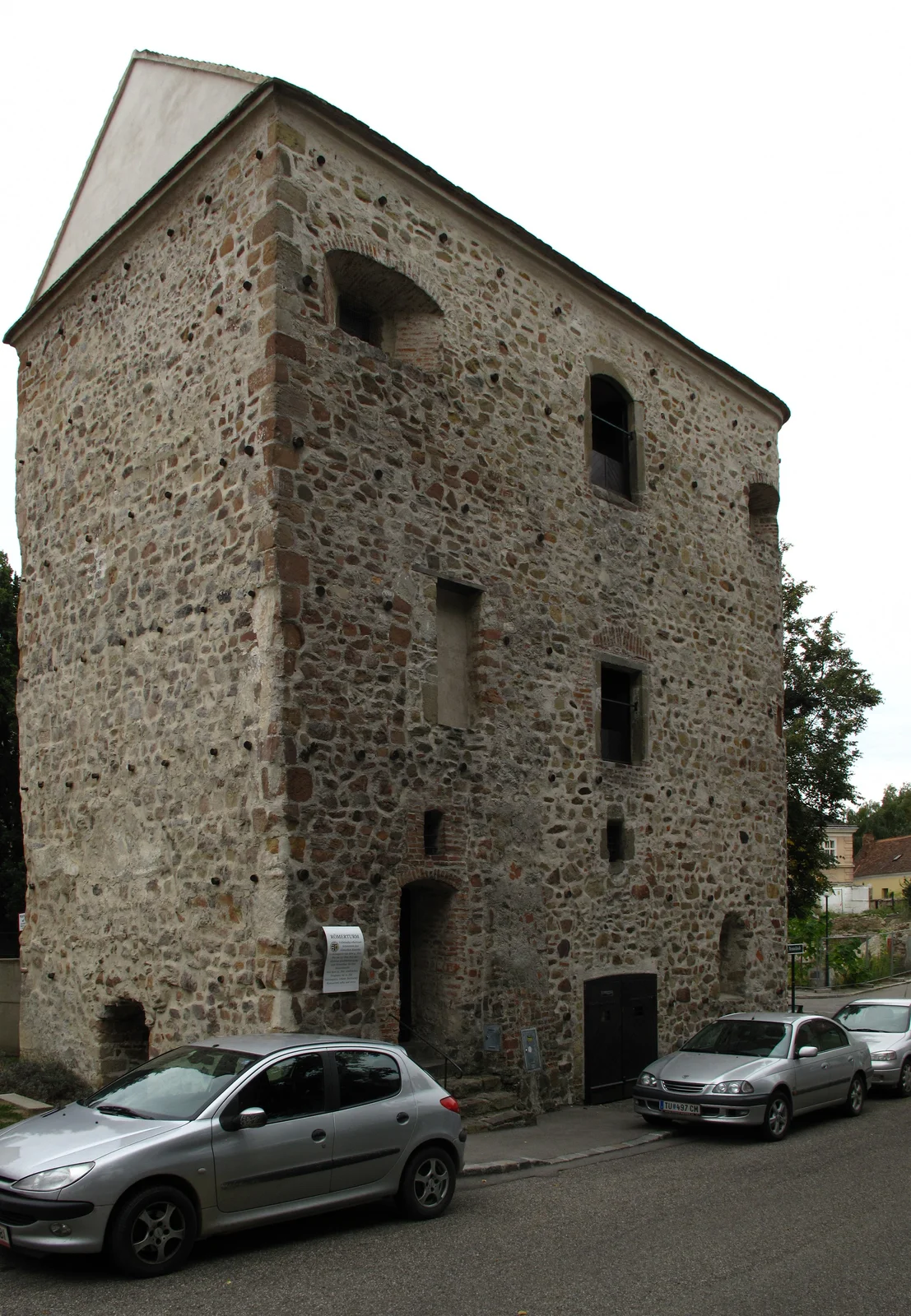
Visitors can explore the old Roman tower in Tulln along the famous Danube bike path.
Modern dam building and river work require careful rescue digs before construction begins.
Conservators use natural lime mortar to stop winter frost from cracking ancient Roman bricks.
Preserved Roman ruins remind modern river towns of their ancient history along the Danube.
A2 · Elementary
Danube River and Roman Limes Fortifications
Roman legionary camps, the Danube river frontier, Carnuntum's Heidentor arch, and modern archaeological conservation in Austria.
The Fluvial Frontier, UNESCO Recognition, and River Patrols
For centuries, the Danube River formed the northern military frontier dividing the Roman Empire from Germanic lands.
UNESCO inscribed the Danube Limes Western Segment as a transnational World Heritage property in 2021.
Roman military planners erected an unbroken chain of legionary bases, auxiliary forts, and stone signal towers.
Patrol vessels belonging to the Classis Pannonica fleet secured river shipping and monitored merchant traffic.
Between Passau and Hainburg, the Danube winds through narrow rocky canyons and wide gravel valleys.
Austrian archaeological surveys confirm more than thirty individual Roman military installations along the river.
The Imperial Capital at Carnuntum and Fort Vindobona
Carnuntum developed into the premier legionary fortress and administrative capital of Upper Pannonia.
The fourth-century Heidentor triumphal arch remains an imposing Roman monument standing outside Carnuntum.
At Petronell-Carnuntum, visitors tour reconstructed Roman townhouses and an arena holding thirteen thousand spectators.
Vindobona, which later became modern Vienna, originated as a major legionary fortress commanding the river.
Excavations below central Vienna uncover authentic Roman commander quarters, heating systems, and barracks foundations.
Thriving civilian settlements grew beside the military camps, supplying lively market stalls, smithies, and taverns.
Auxiliary Cavalry Garrisons, Fluvial Harbors, and Limes Roads
Auxiliary cavalry units stationed at Comagena in Tulln and Favianis in Mautern defended critical river crossings.
Roman military engineers constructed durable stone quays, boat landings, and wooden harbor facilities beside the water.
Under Emperor Valentinian I, late Roman builders added massive horseshoe-shaped defense towers to fort perimeters.
The paved Roman Limes Road linked every river garrison, allowing rapid tactical communication along the bank.
Frequent seasonal Danube floods gradually deposited deep alluvial mud over abandoned Roman masonry structures.
Vibrant frontier commerce flourished as Roman soldiers exchanged wine, glass, and bronze vessels for northern furs.
Non-Invasive Geophysics, Heritage Law, and the Danube Cycle Route
Geophysical prospecting and aerial laser scans detect buried Roman walls without disturbing modern farmland.
The Austrian Federal Monuments Authority enforces strict legal preservation zones across Danube Limes sites.
A preserved Roman tower in Tulln welcomes travelers cycling along the picturesque Danube Cycle Path.
Modern river infrastructure and navigation projects require preventive rescue excavations before earthwork begins.
Conservation teams apply breathable hydraulic lime mortars to protect fragile Roman bricks from winter frost.
These preserved Roman fortifications highlight the deep ancient origins of today's Austrian Danube settlements.
B1 · Intermediate
Danube River and Roman Limes Fortifications
Imperial Roman ripa defenses, Carnuntum's civilian amphitheatre, late-antique horseshoe towers, and archaeological stewardship in Austria.
The Danube Ripa as a Strategic Imperial Military Border
The Danube River functioned as an imposing natural water frontier, known as the ripa, protecting the provinces of Noricum and Pannonia.
UNESCO officially added the Western Segment of the Danube Limes to the World Heritage List in 2021 as a shared multinational monument.
Roman army commanders constructed an integrated defensive cordon comprising legionary camps, auxiliary forts, and intervisible watchtowers.
Armed patrol flotillas of the Classis Pannonica river navy controlled navigation lanes and checked cross-border movements.
Geologically, the Danube cuts through rugged granite promontories and fertile alluvial basins between Passau and Hainburg.
Archaeological institutes across Austria have documented more than thirty distinct Roman military fortifications along the waterway.
Carnuntum Headquarters, the Heidentor, and Vindobona
Carnuntum evolved into the supreme military headquarters and bustling administrative capital of the province of Pannonia Superior.
The monumental fourth-century Heidentor tetrapylon triumphal arch stands today as the defining architectural icon of Roman Carnuntum.
The preserved civilian quarter at Petronell-Carnuntum displays fully reconstructed mansions, bath complexes, and an arena holding thirteen thousand spectators.
Modern Vienna evolved directly from Vindobona, an elite legionary fortress strategically positioned at the crossroads of the Danube and the Amber Road.
Subterranean archaeological reserves beneath Vienna's Hoher Markt reveal preserved Roman officer quarters and hypocaust heating systems.
Vibrant civilian settlements known as canabae grew outside fortress ramparts, fostering lively markets, pottery workshops, and taverns.
Fluvial Engineering, Cavalry Garrisons, and Late Roman Bastions
Roman auxiliary cavalry garrisons based at Comagena in Tulln and Favianis in Mautern maintained vigilant watch over river transit points.
Roman military engineers dredged river channels and built stone wharves, landing slips, and timber-reinforced harbors.
During the late fourth century, military reforms introduced projecting horseshoe-shaped bastions and thick stone curtain walls.
The well-engineered Roman Limes Road traced the southern riverbank, connecting isolated frontier outposts with provincial hubs.
Periodic catastrophic Danube floods deposited deep layers of sandy alluvial sediment that preserved Roman stone foundations underground.
Active cross-border trade enabled Roman merchants to exchange fine bronze tableware, ceramic vessels, and wine for Germanic livestock.
Prospection Technology, Statutory Protection, and River Tourism
Non-invasive geomagnetic surveys and airborne laser scanning map buried Roman fort layouts beneath Austrian crop fields.
The Austrian Federal Monuments Authority administers protective zoning laws to ensure long-term archaeological stewardship.
Preserved monuments like the Roman tower in Tulln draw cultural tourists traveling along the scenic Danube Cycle Path.
Modern flood defense construction and river channel dredging require coordinated archaeological salvage excavations.
Restoration specialists apply breathable hydraulic lime mortars to safeguard exposed Roman masonry from winter frost spalling.
Austria's conserved Roman frontier heritage demonstrates how ancient military infrastructure shaped modern Danube river communities.
B2 · Upper Intermediate
Danube River and Roman Limes Fortifications
Danube Limes frontier engineering, Carnuntum's provincial capital, late Roman artillery towers, and archaeological conservation in Austria.
The Fluvial Frontier, UNESCO Inscription, and River Fleet Operations
The Danube River formed a vital natural barrier and strategic border demarcation that defended the Roman provinces against Germanic incursions.
In 2021, UNESCO inscribed the Danube Limes Western Segment on the World Heritage List, honoring its exceptional transnational importance.
Roman military engineers organized an interlocking cordon of permanent legionary bases, auxiliary forts, and masonry watchtowers along the southern bank.
Naval patrol squadrons belonging to the Classis Pannonica monitored civilian river traffic and secured logistics lanes against cross-border raids.
The defensive topography of the Austrian Limes between Passau and Hainburg benefited from natural river narrows, steep granite gorges, and broad gravel floodplains.
Comprehensive surveys conducted by the Austrian Academy of Sciences have identified over thirty verified Roman military installations along the river.
Carnuntum's Provincial Hegemony, the Heidentor Arch, and Vindobona
Carnuntum served as the formidable legionary stronghold and provincial administrative capital governing Upper Pannonia along the frontier.
Erected during the fourth century, the monumental Heidentor tetrapylon arch commemorates imperial authority and military prowess at Carnuntum.
The civilian town at Petronell features reconstructed Roman urban residences, luxurious baths, and an amphitheatre accommodating thirteen thousand spectators.
Centuries before becoming Austria's modern capital, Vienna originated as the Roman legionary fortress of Vindobona overlooking the Danube meanders.
Deep excavations below Vienna's historic Michaelerplatz and Hoher Markt expose original Roman officer quarters and fortress foundations.
Prosperous civilian suburbs known as canabae developed beside military ramparts, housing bustling artisans, traders, and soldiers' families.
Riverine Engineering, Cavalry Fortresses, and Late Antique Bastions
Auxiliary cavalry garrisons stationed at Comagena in Tulln and Favianis in Mautern effectively dominated vital river crossings.
Roman army engineers constructed fortified stone wharves, landing ramps, and sheltered river basins to accommodate supply barges.
Under Emperor Valentinian I, engineers reinforced existing forts with thick walls and projecting horseshoe-shaped towers suited for defensive ballistas.
The paved Roman Limes Road ran parallel to the water, facilitating rapid troop redeployment and tactical communications along the frontier.
Centuries of shifting river channels and seasonal flooding buried abandoned Roman masonry beneath meters of protective alluvial silt.
Vigorous cross-border economic relations thrived along the ripa, trading Roman bronze vessels and Mediterranean wine for northern amber.
Geophysical Mapping, Monument Protection, and Heritage Tourism
High-resolution geomagnetic prospection and aerial LiDAR reveal the intricate subterranean architecture of Roman camps without excavation.
The Austrian Federal Monuments Authority implements strict statutory preservation orders across urban and rural Danube Limes sites.
Prominent Roman structures like the fourth-century tower in Tulln engage international cyclists touring the famous Danube Cycle Route.
Contemporary hydraulic engineering and river floodwall projects necessitate rigorous salvage archaeology to recover buried heritage.
Conservators utilize specialized breathable hydraulic lime mortars to protect fragile Roman stone rubble from winter frost spalling.
The enduring stones of the Danube Limes remind contemporary Austrian towns of their foundational ties to Roman river civilization.
C1 · Advanced
Danube River and Roman Limes Fortifications
Imperial ripa defensive architecture, Carnuntum provincial urbanism, Valentinianic tower engineering, and monument preservation in Austria.
The Fluvial Ripa Frontier, Strategic Topography, and UNESCO Status
The swift currents of the Danube River formed an indispensable natural frontier, designated in Roman military doctrine as the imperial ripa.
In 2021, UNESCO inscribed the Danube Limes Western Segment on the World Heritage List, recognizing its outstanding transnational significance.
Roman army planners fortified the southern riverbank with a continuous cordon of legionary fortresses, auxiliary castella, and signal towers.
Specially built patrol flotillas belonging to the Classis Pannonica secured river navigation while supervising civilian commercial crossings.
The varied fluvial terrain traverses rocky crystalline defiles and expansive alluvial floodplains between Passau and Hainburg.
Systematic research by the Austrian Academy of Sciences documents over thirty distinct Roman military fortifications along the Austrian riverbank.
Carnuntum Provincial Capital, Monumental Architecture, and Vindobona
Carnuntum flourished as the primary military headquarters and supreme administrative capital of the Roman province of Pannonia Superior.
The fourth-century Heidentor tetrapylon stands as an extraordinary triumphal arch commemorating imperial majesty across the eastern frontier.
The extensive civilian quarter in Petronell-Carnuntum incorporates reconstructed townhouses, thermal baths, and an arena for thirteen thousand spectators.
The strategic Roman legionary fortress of Vindobona guarded the vital crossroads of the Danube River and the continental Amber Road.
Archaeological subterranean reserves beneath Vienna's Hoher Markt protect preserved stone foundations, officer quarters, and ancient street pavements.
Prosperous civilian settlements developed outside camp ramparts, generating thriving trade networks, craft guilds, and domestic residences.
Cavalry Castella, Fluvial Infrastructure, and Late Roman Reforms
Auxiliary cavalry garrisons stationed at Comagena in modern Tulln and Favianis in Mautern maintained strict surveillance over river crossings.
Roman military engineers constructed stone quays, boat slips, and sheltered timber wharves to support supply vessels.
Fourth-century architectural reforms under Emperor Valentinian I introduced projecting horseshoe-shaped bastions capable of supporting torsion artillery.
The durable Roman Limes Road traced the river terrace, ensuring rapid communication and troop movements between distant outposts.
Migrating river meanders and repeated seasonal floods deposited deep layers of fine alluvial sediment over abandoned Roman foundations.
Lucrative trans-Danubian trade flourished across the ripa, exchanging Roman bronze tableware, ceramics, and wine for northern furs.
Non-Invasive Prospection, Monument Laws, and Cultural Tourism
Advanced geomagnetic prospection and airborne LiDAR imaging map complete subsurface plans of Roman settlements without exploratory trenching.
The Austrian Federal Monuments Authority enforces strict statutory zoning to guarantee long-term archaeological stewardship.
Intact Roman landmarks such as the late-antique tower in Tulln draw cultural travelers journeying along the popular Danube Cycle Path.
Modern water management infrastructure and river flood protection schemes mandate comprehensive salvage excavations before construction begins.
Specialist conservators utilize breathable hydraulic lime mortars to protect fragile excavated Roman masonry from winter frost spalling.
Austria's conserved Roman frontier monuments highlight the ancient fluvial roots that continue to define modern Danube communities.
C2 · Mastery
Danube River and Roman Limes Fortifications
Imperial ripa defensive networks, Carnuntum provincial urbanism, Valentinianic artillery bastions, and statutory conservation in Austria.
The Fluvial Frontier, Territorial Demarcation, and UNESCO Inscription
The formidable Danube River served as an unyielding natural boundary and territorial demarcation separating imperial Rome from Germanic populations.
In 2021, UNESCO officially recognized the Danube Limes Western Segment as a transnational World Heritage property of exceptional value.
Imperial military architects established an interlocking defensive cordon consisting of permanent legionary camps, auxiliary castella, and watchtowers.
Specialized naval patrol squadrons of the Classis Pannonica maintained tactical command of the river and intercepted illicit cross-border movements.
The defensive topography of the Austrian Limes exploited steep granite gorges and wide alluvial floodplains between Passau and Hainburg.
Decades of systematic archaeological fieldwork have cataloged more than thirty individual Roman military fortifications along the Austrian river corridor.
Carnuntum's Imperial Hegemony, the Heidentor Arch, and Vindobona
Carnuntum attained immense strategic hegemony as the premier legionary headquarters and administrative capital of the province of Pannonia Superior.
The fourth-century Heidentor tetrapylon stands as an exceptional triumphal arch, symbolizing imperial authority along the Danube frontier.
The archaeological park at Petronell-Carnuntum displays fully reconstructed urban townhouses, bath facilities, and an amphitheatre accommodating thirteen thousand spectators.
Modern Vienna evolved directly from Vindobona, an elite legionary fortress strategically positioned at the crossroads of the Danube and ancient trade arteries.
In situ archaeological crypts beneath Vienna's Hoher Markt exhibit Roman officer quarters and preserved military barracks foundations.
Prosperous civilian settlements known as canabae surrounded legionary strongholds, sustaining lively marketplaces, craft manufacturing, and diverse municipal populations.
Cavalry Castella, Riverine Harbor Engineering, and Valentinianic Bastions
Mobile auxiliary cavalry garrisons stationed at Comagena in Tulln and Favianis in Mautern commanded vital river crossings.
Roman military engineers constructed sophisticated stone quays, landing slips, and timber piers to support river supply navigation.
Fourth-century military reforms under Emperor Valentinian I refitted older river forts with projecting horseshoe-shaped artillery towers and reinforced ramparts.
The paved Roman Limes Road traced the riverbank terrace, enabling rapid tactical redeployment across the imperial frontier.
Centuries of migrating river meanders and catastrophic seasonal inundations covered abandoned Roman stone masonry with thick alluvial silt.
Dynamic trans-frontier economic exchange flourished along the ripa, trading Roman bronze vessels and Italian wine for Germanic raw materials.
Geophysical Prospection, Monument Preservation, and Civic Heritage
Non-invasive geomagnetic prospection and aerial laser scanning document intricate subsurface Roman streetscapes without physical excavation.
The Austrian Federal Monuments Authority enforces comprehensive statutory heritage protection across both municipal and rural Danube Limes sites.
Iconic monuments like the conserved Roman horseshoe tower at Tulln engage cycling travelers along the celebrated Danube Cycle Route.
Modern flood protection infrastructure and commercial waterway improvements mandate rigorous preventive salvage excavations to rescue threatened antiquities.
Professional conservators employ breathable hydraulic lime mortars to insulate fragile Roman stone rubble and brickwork against seasonal frost damage.
Austria's preserved Roman frontier monuments reflect the enduring civilizational legacy that laid the physical foundations for contemporary Danube settlements.
Check your understanding
Choose how closely you want to revisit the article. You can refer back while answering, and review explanations when you finish.
Quick Quiz A1
Try one question, then create a free account for the full Quick Quiz. Sign Up Free
Answer every question before checking. There is no time limit.
Your results
/ 1 correct (%)
Read the explanations to see how each answer connects to the article.
-
Which major river formed the natural northern military border of the Roman Empire in Austria?
1. Answer:
Quick Quiz A2
Try one question, then create a free account for the full Quick Quiz. Sign Up Free
Answer every question before checking. There is no time limit.
Your results
/ 1 correct (%)
Read the explanations to see how each answer connects to the article.
-
Which major river formed the natural northern military border of the Roman Empire in Austria?
1. Answer:
Quick Quiz B1
Try one question, then create a free account for the full Quick Quiz. Sign Up Free
Answer every question before checking. There is no time limit.
Your results
/ 1 correct (%)
Read the explanations to see how each answer connects to the article.
-
Which major river formed the natural northern military border of the Roman Empire in Austria?
1. Answer:
Quick Quiz B2
Try one question, then create a free account for the full Quick Quiz. Sign Up Free
Answer every question before checking. There is no time limit.
Your results
/ 1 correct (%)
Read the explanations to see how each answer connects to the article.
-
Which major river formed the natural northern military border of the Roman Empire in Austria?
1. Answer:
Quick Quiz C1
Try one question, then create a free account for the full Quick Quiz. Sign Up Free
Answer every question before checking. There is no time limit.
Your results
/ 1 correct (%)
Read the explanations to see how each answer connects to the article.
-
Which major river formed the natural northern military border of the Roman Empire in Austria?
1. Answer:
Quick Quiz C2
Try one question, then create a free account for the full Quick Quiz. Sign Up Free
Answer every question before checking. There is no time limit.
Your results
/ 1 correct (%)
Read the explanations to see how each answer connects to the article.
-
Which major river formed the natural northern military border of the Roman Empire in Austria?
1. Answer:
