A1 · Beginner
The Marowijne River: Fluvial Borderlands and Forest Waterways
From rushing interior rapids and long wooden pirogues to busy border river crossings and turtle nesting beaches, the Marowijne links two worlds.
Hydrology, Tributaries, and Fluvial Geography
The big Marowijne River is 680 kilometers long and marks the eastern frontier between Suriname and French Guiana.
The river starts where the Lawa and Tapanahony streams meet in the green interior forest highlands.
Strong water runs across ancient granitic bedrock, forming many dangerous rapids and rocky cataracts called soela's.
Heavy summer rains raise water levels, sending huge seasonal flood flows through the river channel.
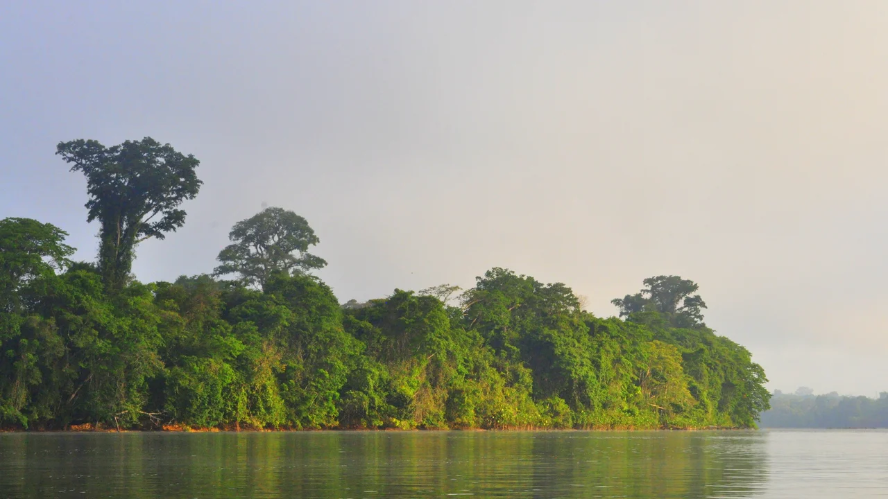
Near the coast, the lower river widens into a broad channel before meeting the blue Atlantic Ocean.
Salty sea water pushes inland during dry months, feeding thick green mangrove wetlands along wet muddy banks.
Maroon Navigation and Pirogue Corridors
Skilled Ndyuka and Aluku Maroon boatmasters called bootlieden know every rocky bend in the river rapids.
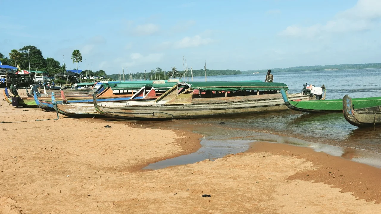
Long wooden dugout boats called korjalen have strong outboard motors to move passengers and food across water.
Boat crews work together using long wooden poles to guide boats safely through white water rapids.
Historic riverside villages like Stoelmanseiland, Drietabbetje, and Cottica sit along sandy boat landing steps.
The open river connects family groups and local trading markets across the border between both countries.
Boats carry big fuel drums, wood planks, farm crops, and mining tools up the long river corridor.
Borderland Towns and Transboundary Commerce
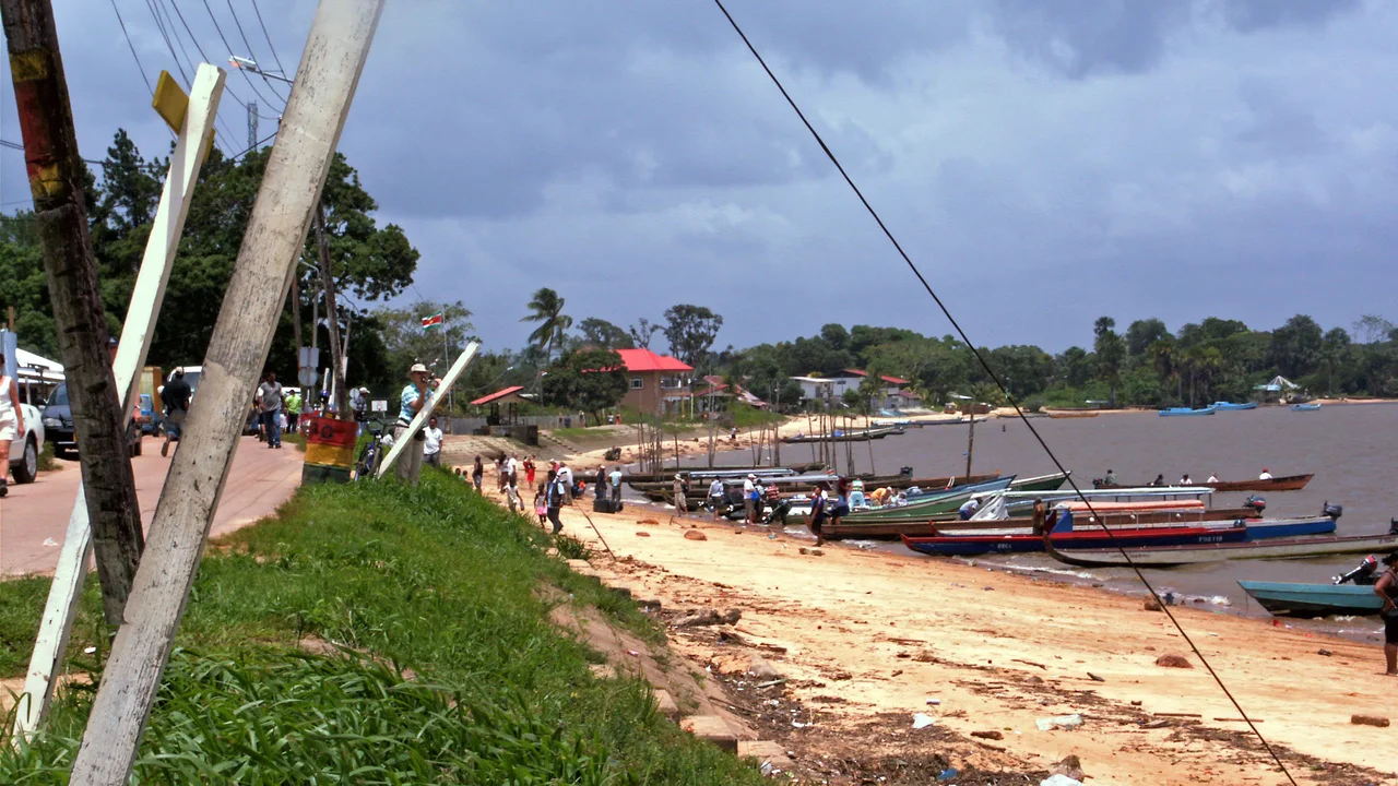
The busy border town of Albina in Suriname sits two kilometers across the water from Saint-Laurent in French Guiana.
Fast small water taxis carry smiling travelers every day between the river wharves of Albina and Saint-Laurent.
People trade food and shop across the water because prices differ between Surinamese dollars and European euros.
A large international car ferry called La Gabrielle moves cars and supply trucks across the wide river.
Border guards and customs offices in Albina check travel passports and inspect commercial cargo bags.
River silt washes into port docks, so city workers dredge the river channel to keep boat paths open.
Estuarine Conservation and Riparian Threats
The Galibi Nature Reserve at the river mouth protects ocean nesting beaches for large sea turtles.
Indigenous Kali'na people in coastal villages guide nature visitors and protect turtle nests on sandy beaches.
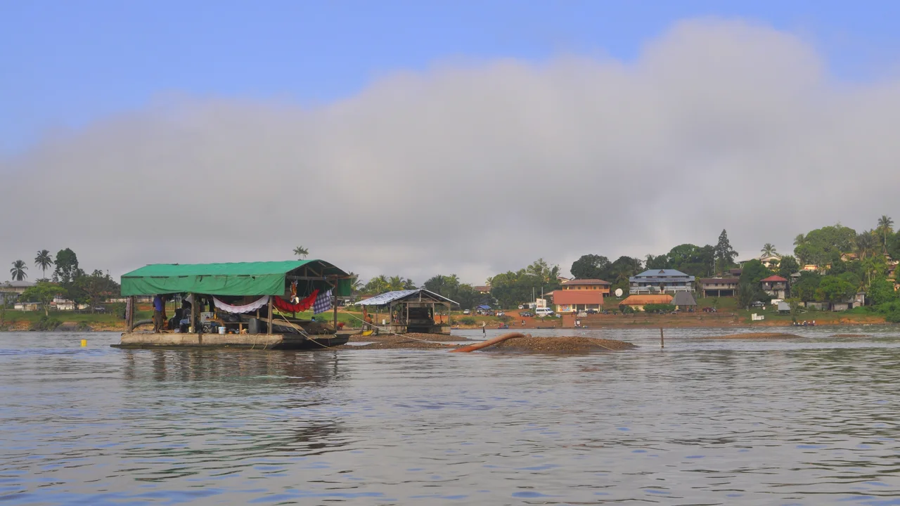
Illegal gold mining on forest creeks washes thick yellow mud into the river and harms water clarity.
Harmful mercury from gold panning enters river fish and threatens traditional fishing communities.
Joint border science teams test river water samples to find chemical pollution and protect human health.
Nature agreements help local fishing villages protect clean coastal waters from harmful forest mining.
A2 · Elementary
The Marowijne River: Hydrology, Maroon Navigation, and Border Trade
Analyzing Guiana Shield headwaters, Ndyuka and Aluku korjaal navigation, Albina border crossings, and estuarine conservation.
Hydrology, Tributaries, and Fluvial Geography
Extending approximately 680 kilometers, the Marowijne River forms the natural international frontier separating eastern Suriname from overseas French Guiana.
The river originates from the hydraulic confluence of the Lawa and Tapanahony rivers deep within the primary rainforest highlands of the Guiana Shield.
Flowing northward over ancient Precambrian granitic bedrock, the upper river basin is punctuated by hundreds of turbulent rapids and foaming cataracts known locally as soela's.
Intense equatorial precipitation drives extreme seasonal discharge variations, where peak monsoon floods exceed 6,000 cubic meters per second during wet periods.
Nearing the coast, the lower river course expands into an immense estuarine channel several kilometers wide before emptying directly into the Atlantic Ocean.
Strong tidal saline intrusion penetrates dozens of kilometers inland during dry low-water months, sustaining extensive brackish mangrove wetland zones along riparian mudflats.
Maroon Navigation and Pirogue Corridors
For more than two centuries, skilled Ndyuka and Aluku Maroon boatmasters known as bootlieden have mastered navigation across the treacherous rapids of the river corridor.
Slender wooden dugout pirogues known as korjalen, skillfully hollowed from single rainforest tree trunks and equipped with powerful outboard engines, serve as primary passenger and freight craft.
Conquering surging upstream cataracts requires seamless teamwork between the stern motor helmsman and the vigilant bow watchman wielding a sturdy wooden maneuvering pole.
Historic Maroon riparian settlement networks, notably Stoelmanseiland, Drietabbetje, and Cottica, are clustered directly along the riverbanks around communal canoe landing stages.
Transcending formal colonial boundaries, the waterway functions as an open fluvial highway connecting matrilineal kinship lineages and mutual barter economies on both shorelines.
Essential logistics cargoes including heavy diesel fuel drums, timber building supplies, cultivated cassava tubers, and inland gold mining provisions traverse the river daily from coastal depots.
Borderland Towns and Transboundary Commerce
On the western Surinamese shore, the bustling border port of Albina looks directly across a two-kilometer water expanse toward Saint-Laurent-du-Maroni in French Guiana.
A vibrant fleet of motorized passenger water taxis carries commuters, shoppers, and travelers between the official immigration wharves of Albina and Saint-Laurent daily.
Cross-border informal commerce thrives on structural price differentials, consumer supply asymmetries, and exchange fluctuations between the Surinamese dollar and the euro.
Connecting the international road network, the roll-on vehicular ferry La Gabrielle provides scheduled maritime transport for commercial freight trucks and private vehicles across the frontier.
National customs agencies, police checkpoints, and immigration stations at Albina manage border inspection procedures, passport stamps, and commercial tariff collection.
Persistent fluvial siltation along active berthing wharves requires periodic bilateral dredging coordination between Surinamese water authorities and French port engineers.
Estuarine Conservation and Riparian Threats
Situated along the river mouth estuary, the Galibi Nature Reserve protects globally significant sandy Atlantic nesting beaches for endangered leatherback and green sea turtles.
Indigenous Kali'na communities living in the coastal villages of Christiaankondre and Langamankondre actively co-manage wildlife monitoring patrols and guided ecotourism initiatives.
Expanding unregulated alluvial gold mining operations in upper jungle tributaries release massive quantities of washed clay sediment, causing severe downstream water turbidity.
Widespread use of elemental mercury in artisanal gold extraction introduces toxic heavy metals into the fluvial food web, triggering dangerous bioaccumulation in predatory river fish.
In response to ecological degradation, joint binational scientific commissions conduct regular chemical water sampling to monitor riparian pollution levels and hydrological health.
Emerging transboundary watershed agreements stress community-led estuarine fisheries management alongside a strict prohibition on industrial gold dredging within delicate coastal nature reserves.
B1 · Intermediate
Fluvial Borderlands, Maroon Pirogue Networks, and Riparian Ecology along the Marowijne
An analytical study of international boundary hydrology, rapids navigation systems, cross-border commerce, and estuarine turtle habitats.
Hydrology, Tributaries, and Fluvial Geography
Extending approximately 680 kilometers, the Marowijne River forms the natural international frontier separating eastern Suriname from overseas French Guiana.
The river originates from the hydraulic confluence of the Lawa and Tapanahony rivers deep within the primary rainforest highlands of the Guiana Shield.
Flowing northward over ancient Precambrian granitic bedrock, the upper river basin is punctuated by hundreds of turbulent rapids and foaming cataracts known locally as soela's.
Intense equatorial precipitation drives extreme seasonal discharge variations, where peak monsoon floods exceed 6,000 cubic meters per second during wet periods.
Nearing the coast, the lower river course expands into an immense estuarine channel several kilometers wide before emptying directly into the Atlantic Ocean.
Strong tidal saline intrusion penetrates dozens of kilometers inland during dry low-water months, sustaining extensive brackish mangrove wetland zones along riparian mudflats.
Maroon Navigation and Pirogue Corridors
For more than two centuries, skilled Ndyuka and Aluku Maroon boatmasters known as bootlieden have mastered navigation across the treacherous rapids of the river corridor.
Slender wooden dugout pirogues known as korjalen, skillfully hollowed from single rainforest tree trunks and equipped with powerful outboard engines, serve as primary passenger and freight craft.
Conquering surging upstream cataracts requires seamless teamwork between the stern motor helmsman and the vigilant bow watchman wielding a sturdy wooden maneuvering pole.
Historic Maroon riparian settlement networks, notably Stoelmanseiland, Drietabbetje, and Cottica, are clustered directly along the riverbanks around communal canoe landing stages.
Transcending formal colonial boundaries, the waterway functions as an open fluvial highway connecting matrilineal kinship lineages and mutual barter economies on both shorelines.
Essential logistics cargoes including heavy diesel fuel drums, timber building supplies, cultivated cassava tubers, and inland gold mining provisions traverse the river daily from coastal depots.
Borderland Towns and Transboundary Commerce
On the western Surinamese shore, the bustling border port of Albina looks directly across a two-kilometer water expanse toward Saint-Laurent-du-Maroni in French Guiana.
A vibrant fleet of motorized passenger water taxis carries commuters, shoppers, and travelers between the official immigration wharves of Albina and Saint-Laurent daily.
Cross-border informal commerce thrives on structural price differentials, consumer supply asymmetries, and exchange fluctuations between the Surinamese dollar and the euro.
Connecting the international road network, the roll-on vehicular ferry La Gabrielle provides scheduled maritime transport for commercial freight trucks and private vehicles across the frontier.
National customs agencies, police checkpoints, and immigration stations at Albina manage border inspection procedures, passport stamps, and commercial tariff collection.
Persistent fluvial siltation along active berthing wharves requires periodic bilateral dredging coordination between Surinamese water authorities and French port engineers.
Estuarine Conservation and Riparian Threats
Situated along the river mouth estuary, the Galibi Nature Reserve protects globally significant sandy Atlantic nesting beaches for endangered leatherback and green sea turtles.
Indigenous Kali'na communities living in the coastal villages of Christiaankondre and Langamankondre actively co-manage wildlife monitoring patrols and guided ecotourism initiatives.
Expanding unregulated alluvial gold mining operations in upper jungle tributaries release massive quantities of washed clay sediment, causing severe downstream water turbidity.
Widespread use of elemental mercury in artisanal gold extraction introduces toxic heavy metals into the fluvial food web, triggering dangerous bioaccumulation in predatory river fish.
In response to ecological degradation, joint binational scientific commissions conduct regular chemical water sampling to monitor riparian pollution levels and hydrological health.
Emerging transboundary watershed agreements stress community-led estuarine fisheries management alongside a strict prohibition on industrial gold dredging within delicate coastal nature reserves.
B2 · Upper Intermediate
The Marowijne River: Fluvial Morphology, Transboundary Mobility, and Watershed Governance
Investigating seasonal flood discharges, Maroon socio-spatial river corridors, Albina-Saint-Laurent trade asymmetries, and mercury siltation threats.
Hydrology, Tributaries, and Fluvial Geography
Extending approximately 680 kilometers, the Marowijne River forms the natural international frontier separating eastern Suriname from overseas French Guiana.
The river originates from the hydraulic confluence of the Lawa and Tapanahony rivers deep within the primary rainforest highlands of the Guiana Shield.
Flowing northward over ancient Precambrian granitic bedrock, the upper river basin is punctuated by hundreds of turbulent rapids and foaming cataracts known locally as soela's.
Intense equatorial precipitation drives extreme seasonal discharge variations, where peak monsoon floods exceed 6,000 cubic meters per second during wet periods.
Nearing the coast, the lower river course expands into an immense estuarine channel several kilometers wide before emptying directly into the Atlantic Ocean.
Strong tidal saline intrusion penetrates dozens of kilometers inland during dry low-water months, sustaining extensive brackish mangrove wetland zones along riparian mudflats.
Maroon Navigation and Pirogue Corridors
For more than two centuries, skilled Ndyuka and Aluku Maroon boatmasters known as bootlieden have mastered navigation across the treacherous rapids of the river corridor.
Slender wooden dugout pirogues known as korjalen, skillfully hollowed from single rainforest tree trunks and equipped with powerful outboard engines, serve as primary passenger and freight craft.
Conquering surging upstream cataracts requires seamless teamwork between the stern motor helmsman and the vigilant bow watchman wielding a sturdy wooden maneuvering pole.
Historic Maroon riparian settlement networks, notably Stoelmanseiland, Drietabbetje, and Cottica, are clustered directly along the riverbanks around communal canoe landing stages.
Transcending formal colonial boundaries, the waterway functions as an open fluvial highway connecting matrilineal kinship lineages and mutual barter economies on both shorelines.
Essential logistics cargoes including heavy diesel fuel drums, timber building supplies, cultivated cassava tubers, and inland gold mining provisions traverse the river daily from coastal depots.
Borderland Towns and Transboundary Commerce
On the western Surinamese shore, the bustling border port of Albina looks directly across a two-kilometer water expanse toward Saint-Laurent-du-Maroni in French Guiana.
A vibrant fleet of motorized passenger water taxis carries commuters, shoppers, and travelers between the official immigration wharves of Albina and Saint-Laurent daily.
Cross-border informal commerce thrives on structural price differentials, consumer supply asymmetries, and exchange fluctuations between the Surinamese dollar and the euro.
Connecting the international road network, the roll-on vehicular ferry La Gabrielle provides scheduled maritime transport for commercial freight trucks and private vehicles across the frontier.
National customs agencies, police checkpoints, and immigration stations at Albina manage border inspection procedures, passport stamps, and commercial tariff collection.
Persistent fluvial siltation along active berthing wharves requires periodic bilateral dredging coordination between Surinamese water authorities and French port engineers.
Estuarine Conservation and Riparian Threats
Situated along the river mouth estuary, the Galibi Nature Reserve protects globally significant sandy Atlantic nesting beaches for endangered leatherback and green sea turtles.
Indigenous Kali'na communities living in the coastal villages of Christiaankondre and Langamankondre actively co-manage wildlife monitoring patrols and guided ecotourism initiatives.
Expanding unregulated alluvial gold mining operations in upper jungle tributaries release massive quantities of washed clay sediment, causing severe downstream water turbidity.
Widespread use of elemental mercury in artisanal gold extraction introduces toxic heavy metals into the fluvial food web, triggering dangerous bioaccumulation in predatory river fish.
In response to ecological degradation, joint binational scientific commissions conduct regular chemical water sampling to monitor riparian pollution levels and hydrological health.
Emerging transboundary watershed agreements stress community-led estuarine fisheries management alongside a strict prohibition on industrial gold dredging within delicate coastal nature reserves.
C1 · Advanced
The Political Hydrology and Cultural Geography of the Marowijne River Basin
A critical investigation examining Precambrian cataract geomorphology, Maroon fluvial highways, borderland informal exchange, and transboundary environmental stewardship.
Hydrology, Tributaries, and Fluvial Geography
Extending approximately 680 kilometers, the Marowijne River forms the natural international frontier separating eastern Suriname from overseas French Guiana.
The river originates from the hydraulic confluence of the Lawa and Tapanahony rivers deep within the primary rainforest highlands of the Guiana Shield.
Flowing northward over ancient Precambrian granitic bedrock, the upper river basin is punctuated by hundreds of turbulent rapids and foaming cataracts known locally as soela's.
Intense equatorial precipitation drives extreme seasonal discharge variations, where peak monsoon floods exceed 6,000 cubic meters per second during wet periods.
Nearing the coast, the lower river course expands into an immense estuarine channel several kilometers wide before emptying directly into the Atlantic Ocean.
Strong tidal saline intrusion penetrates dozens of kilometers inland during dry low-water months, sustaining extensive brackish mangrove wetland zones along riparian mudflats.
Maroon Navigation and Pirogue Corridors
For more than two centuries, skilled Ndyuka and Aluku Maroon boatmasters known as bootlieden have mastered navigation across the treacherous rapids of the river corridor.
Slender wooden dugout pirogues known as korjalen, skillfully hollowed from single rainforest tree trunks and equipped with powerful outboard engines, serve as primary passenger and freight craft.
Conquering surging upstream cataracts requires seamless teamwork between the stern motor helmsman and the vigilant bow watchman wielding a sturdy wooden maneuvering pole.
Historic Maroon riparian settlement networks, notably Stoelmanseiland, Drietabbetje, and Cottica, are clustered directly along the riverbanks around communal canoe landing stages.
Transcending formal colonial boundaries, the waterway functions as an open fluvial highway connecting matrilineal kinship lineages and mutual barter economies on both shorelines.
Essential logistics cargoes including heavy diesel fuel drums, timber building supplies, cultivated cassava tubers, and inland gold mining provisions traverse the river daily from coastal depots.
Borderland Towns and Transboundary Commerce
On the western Surinamese shore, the bustling border port of Albina looks directly across a two-kilometer water expanse toward Saint-Laurent-du-Maroni in French Guiana.
A vibrant fleet of motorized passenger water taxis carries commuters, shoppers, and travelers between the official immigration wharves of Albina and Saint-Laurent daily.
Cross-border informal commerce thrives on structural price differentials, consumer supply asymmetries, and exchange fluctuations between the Surinamese dollar and the euro.
Connecting the international road network, the roll-on vehicular ferry La Gabrielle provides scheduled maritime transport for commercial freight trucks and private vehicles across the frontier.
National customs agencies, police checkpoints, and immigration stations at Albina manage border inspection procedures, passport stamps, and commercial tariff collection.
Persistent fluvial siltation along active berthing wharves requires periodic bilateral dredging coordination between Surinamese water authorities and French port engineers.
Estuarine Conservation and Riparian Threats
Situated along the river mouth estuary, the Galibi Nature Reserve protects globally significant sandy Atlantic nesting beaches for endangered leatherback and green sea turtles.
Indigenous Kali'na communities living in the coastal villages of Christiaankondre and Langamankondre actively co-manage wildlife monitoring patrols and guided ecotourism initiatives.
Expanding unregulated alluvial gold mining operations in upper jungle tributaries release massive quantities of washed clay sediment, causing severe downstream water turbidity.
Widespread use of elemental mercury in artisanal gold extraction introduces toxic heavy metals into the fluvial food web, triggering dangerous bioaccumulation in predatory river fish.
In response to ecological degradation, joint binational scientific commissions conduct regular chemical water sampling to monitor riparian pollution levels and hydrological health.
Emerging transboundary watershed agreements stress community-led estuarine fisheries management alongside a strict prohibition on industrial gold dredging within delicate coastal nature reserves.
C2 · Mastery
Riparian Sovereignty, Fluvial Mobility, and Estuarine Ecology along the Marowijne
A comprehensive analytical monograph exploring Suriname eastern river frontier across hydrological, ethnographic, geopolitical, and conservation dimensions.
Hydrology, Tributaries, and Fluvial Geography
Extending approximately 680 kilometers, the Marowijne River forms the natural international frontier separating eastern Suriname from overseas French Guiana.
The river originates from the hydraulic confluence of the Lawa and Tapanahony rivers deep within the primary rainforest highlands of the Guiana Shield.
Flowing northward over ancient Precambrian granitic bedrock, the upper river basin is punctuated by hundreds of turbulent rapids and foaming cataracts known locally as soela's.
Intense equatorial precipitation drives extreme seasonal discharge variations, where peak monsoon floods exceed 6,000 cubic meters per second during wet periods.
Nearing the coast, the lower river course expands into an immense estuarine channel several kilometers wide before emptying directly into the Atlantic Ocean.
Strong tidal saline intrusion penetrates dozens of kilometers inland during dry low-water months, sustaining extensive brackish mangrove wetland zones along riparian mudflats.
Maroon Navigation and Pirogue Corridors
For more than two centuries, skilled Ndyuka and Aluku Maroon boatmasters known as bootlieden have mastered navigation across the treacherous rapids of the river corridor.
Slender wooden dugout pirogues known as korjalen, skillfully hollowed from single rainforest tree trunks and equipped with powerful outboard engines, serve as primary passenger and freight craft.
Conquering surging upstream cataracts requires seamless teamwork between the stern motor helmsman and the vigilant bow watchman wielding a sturdy wooden maneuvering pole.
Historic Maroon riparian settlement networks, notably Stoelmanseiland, Drietabbetje, and Cottica, are clustered directly along the riverbanks around communal canoe landing stages.
Transcending formal colonial boundaries, the waterway functions as an open fluvial highway connecting matrilineal kinship lineages and mutual barter economies on both shorelines.
Essential logistics cargoes including heavy diesel fuel drums, timber building supplies, cultivated cassava tubers, and inland gold mining provisions traverse the river daily from coastal depots.
Borderland Towns and Transboundary Commerce
On the western Surinamese shore, the bustling border port of Albina looks directly across a two-kilometer water expanse toward Saint-Laurent-du-Maroni in French Guiana.
A vibrant fleet of motorized passenger water taxis carries commuters, shoppers, and travelers between the official immigration wharves of Albina and Saint-Laurent daily.
Cross-border informal commerce thrives on structural price differentials, consumer supply asymmetries, and exchange fluctuations between the Surinamese dollar and the euro.
Connecting the international road network, the roll-on vehicular ferry La Gabrielle provides scheduled maritime transport for commercial freight trucks and private vehicles across the frontier.
National customs agencies, police checkpoints, and immigration stations at Albina manage border inspection procedures, passport stamps, and commercial tariff collection.
Persistent fluvial siltation along active berthing wharves requires periodic bilateral dredging coordination between Surinamese water authorities and French port engineers.
Estuarine Conservation and Riparian Threats
Situated along the river mouth estuary, the Galibi Nature Reserve protects globally significant sandy Atlantic nesting beaches for endangered leatherback and green sea turtles.
Indigenous Kali'na communities living in the coastal villages of Christiaankondre and Langamankondre actively co-manage wildlife monitoring patrols and guided ecotourism initiatives.
Expanding unregulated alluvial gold mining operations in upper jungle tributaries release massive quantities of washed clay sediment, causing severe downstream water turbidity.
Widespread use of elemental mercury in artisanal gold extraction introduces toxic heavy metals into the fluvial food web, triggering dangerous bioaccumulation in predatory river fish.
In response to ecological degradation, joint binational scientific commissions conduct regular chemical water sampling to monitor riparian pollution levels and hydrological health.
Emerging transboundary watershed agreements stress community-led estuarine fisheries management alongside a strict prohibition on industrial gold dredging within delicate coastal nature reserves.
Check your understanding
Choose how closely you want to revisit the article. You can refer back while answering, and review explanations when you finish.
Quick Quiz A1
Try one question, then create a free account for the full Quick Quiz. Sign Up Free
Answer every question before checking. There is no time limit.
Your results
/ 1 correct (%)
Read the explanations to see how each answer connects to the article.
-
How long is the big Marowijne River marking the frontier between Suriname and French Guiana?
1. Answer:
Quick Quiz A2
Try one question, then create a free account for the full Quick Quiz. Sign Up Free
Answer every question before checking. There is no time limit.
Your results
/ 1 correct (%)
Read the explanations to see how each answer connects to the article.
-
How long is the Marowijne River as it forms the frontier between Suriname and French Guiana?
1. Answer:
Quick Quiz B1
Try one question, then create a free account for the full Quick Quiz. Sign Up Free
Answer every question before checking. There is no time limit.
Your results
/ 1 correct (%)
Read the explanations to see how each answer connects to the article.
-
How long is the Marowijne River as it forms the frontier between Suriname and French Guiana?
1. Answer:
Quick Quiz B2
Try one question, then create a free account for the full Quick Quiz. Sign Up Free
Answer every question before checking. There is no time limit.
Your results
/ 1 correct (%)
Read the explanations to see how each answer connects to the article.
-
How long is the Marowijne River as it forms the frontier between Suriname and French Guiana?
1. Answer:
Quick Quiz C1
Try one question, then create a free account for the full Quick Quiz. Sign Up Free
Answer every question before checking. There is no time limit.
Your results
/ 1 correct (%)
Read the explanations to see how each answer connects to the article.
-
How long is the Marowijne River as it forms the frontier between Suriname and French Guiana?
1. Answer:
Quick Quiz C2
Try one question, then create a free account for the full Quick Quiz. Sign Up Free
Answer every question before checking. There is no time limit.
Your results
/ 1 correct (%)
Read the explanations to see how each answer connects to the article.
-
How long is the Marowijne River as it forms the frontier between Suriname and French Guiana?
1. Answer:
